12hrs of almost constant physical sport activity is a number far beyond most people's comprehension. Chris Roda and I embarked on a journey of unimaginable vastness. Both with incredible athletic capabilities, yet both still beginners in the world of orienteering, at least compared to those who enlisted in the 12hr. The unknown and unexpected is what gets things excited for us--experiencing new environments and accepting the inevitable twists which lie ahead.
We drove up to De Leon Springs Park and got there around 1am. It was pitch dark at the park. I turned on my new tool, the Inova T5, as recommended by Ron Eaglin, and the nightly world was lit up like the heavens. It literally emitted a beam to the moon and burned a hole in the ground--it was that bright.
T5 (left) vs Maglite LED (right)

(racer's meeting at 3am)


(race instructions)


Foot 1
The race started at 4am, slightly chilly. I think there was around 20 teams and everyone was pumped at the starting line. Once started, everyone jogged to the first CP. The first half of the first leg portion was just chaos, like a Warrior Dash in the night, where my T5 lit up the ground well enough to prevent a dozen people from breaking ankles in the heavily rooted foot trails. We were lemmings doing what others were doing. It backfired, because we had strategized going from CP2 to CP3, but the mass crowd took us from CP2 to CP6, and we initially thought CP6 was CP3. From there on out, the crowd gradually dissipated, which is what I liked better. I wouldn't learn anything if the crowd just led us to the destinations, otherwise I'd go do triathlons.
(foot and bike map)

Plans changed on the fly, and we went to CP5 and then to CP4. Finding CP4 gave me images of Blair Witch Project (movie), as we shot into the spooky nightly woods a couple times in different places before finding the hanging 'relic'. CP3 took the longest. The clue was "along old fence line SW of trail intersection." The team with the 10yr old finally found it before us, and it turned out the clue was wrong. It seemed the clue should have said "SE of trail intersection." The trek back was straightforward. We spent a respectable 1hr 1min on this section, and my stamina was feeling strong.
Bike 1 - ride to Highland TA to start the boats
On the map, there was a shorter route and a longer route. The shorter route had you following what seemed like a set of railroad tracks, and the longer route was on paved streets. We decided the smooth road would be much less painful, and the speed allowed would make up for the longer distance. We got to the boat TA with barely any hitches. At the TA, we dropped our bikes off into a U-Haul, where they transported it back to the main TA for us. Roda and I grabbed a canoe, strapped our glow sticks on it, and shipped it off into the dark waters.
(street map)

Boat 1 - Lake Woodruff
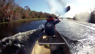
It was still dark at around 6am, and for the first 30min, we could not steer the vessel straight for the life of us. A couple of teams passed us with smooth speed. We knew something was wrong, perhaps paddling technique, so I thought it was just lack of training in the canoes. Once we got out of the initial small channel, I made the huge mistake of calling for us to go left (in our perspective heading south) instead of right towards CP7. I still have no idea why I chose that direction. It costed us a good 30minutes. During the time we were lost, however, Roda got the brilliant idea that we must be paddling the boat backwards. As soon as we turned around, the canoe was set sailing smoothly. I had no idea a canoe was designed differently on both ends, let alone if it made a difference--the difference was huge! Laugh all you want :D It's all apart of our learning experience.
(boat map)

The only scouting I had done on this park ahead of time was looking at Google satellite maps and various maps I found in Ron Eaglin's collection. My main impression was that if we had a course going through Lake Woodruff, it was going to be an all-day adventure because the only paddle training we had were Youtube videos and our small collection of AR races (0 Chris, 2 Hien). Sure enough, the course had us going completely around the perimeter of Lake Woodruff, which was more challenging than I had imagined.
(unloading the canoe at the docks, 6am)

CP7 was easy to find once we were on the right path. Heading up to CP8 revealed how much water vegetation had changed the map. Going in and out of CP8 had us using some Canyonero brute force. At one point, Roda jumped out of the boat to try to pull it over to the CP punch--he fell right in almost water over head.
(if in doubt, brute force through--yes, we are paddling over what looks like green ground)
It took us a long time to paddle up to CP9. I tried identifying the channels we would see along the way, but it seemed none existed in real life anymore. Once we had visibility of Lake Woodruff, I looked back and saw we had rounded a particular turn that was shown in the map. CP9 had to be somewhere after the turn. I called for a search stop, and we tried to find this small canal. We found it pretty quickly and headed to CP10.
(paddling at the crack of dawn)

(paddling at sunrise)

Again, the map showed a small channel heading up the west perimeter of Lake Woodruff. We knew better than to travel up that, but was curious to see what the condition was like. The map also showed a small channel that you can use to exit into Lake Woodruff about a third of the way up should conditions be pretty stubborn. It only took us about 1 minute of paddling to determine the entire channel was blocked by overgrown vegetation. On top of that, the dark, red-stained water reeked of rotten sewage. We headed right back out into the main open waters and decided to make a straight shot to CP14 around the upper right corner of Lake Woodruff at the peninsula. Chris smartly asked me to get a bearing towards the peninsula. I got a rough bearing, looked far ahead in the distance and noticed that there was a section of trees covered by shadow. Roughly 4km away meant that any compass bearing would not hold much accuracy, so pinpointing a spot in the distance was a better tactic. The sun rises in the east, which meant some trees would be covered in shadow at the channel opening, right where the tree boundary rounded. I told Roda we should aim for those shadowed trees, and that it would be incredible if I called that correctly.

(sewage smelling, dirty canal near CP10)

To me, this was the most mentally challenging length of our monotonous exercising--cutting across Lake Woodruff. It was about a 4km length in open water, seeing the same thing the entire duration. The tree line in the distance seemed to have stayed the same distance for the longest time! Chris, however, is a marathon runner and is used training his mind to endure this kind of torture. How many of you like to jump on a treadmill, set it to an hour, and run on it mindlessly til the end? Multiply that by 6, and that's how I saw this canoe leg.

It turned out our 'shadowy tree' identification proved correct. The closer we got, the more activity we saw of boats and other canoes there. We rounded the peninsula that shielded CP11 and spent about 30min looking for it. There was no channel along the west side of the water. Up and down we went, searching for anything that resembled a channel to shoot our canoes into. We went shallowly into a handful of flukes and could not find this. We finally called it off, and looking at the time left, called off CP12 as well.
The return route contained CP's 13-16. The sun had risen higher at this point. We were paddling east with the sun glaring into our face and the winds blowing hard. There were underwater vegetation in some areas that added friction to our speed. We felt everything that slowed us one bit. Our backs were fried, but after repetitively paddling left, right, left, right for almost 6hrs, it had gotten so used to it that our brains weren't registering the fatigue anymore. Other than that, there was no drama to finding the rest of the water CPs. We were dead last returning the canoes and internally screaming to get the heck out of there. At least we beat the declared 11:30am cutoff point by a couple dozen minutes...eh heh.


It is a no-brainer that paddling is our weakest link. We started off crappily but our skills progressed pretty well towards the end. Our post-mortem spoke of skipping the furthest canoe points in the future until we become more on par with average time results. We need to purposely skip it and not even attempt going for far/difficult ones. This is so that we can collect many more points in our stronger disciplines.
Bike 2 - Chuck Lennon Trail Head

We walked back to the main transition area to proceed to Chuck Lennon Trail Head. None of us could really figure out where the road leading to it was, and after my failed attempt to go down the wrong path in the parking lot, we admittedly asked the man at the information booth where it was. We were getting pretty desperate at this point.
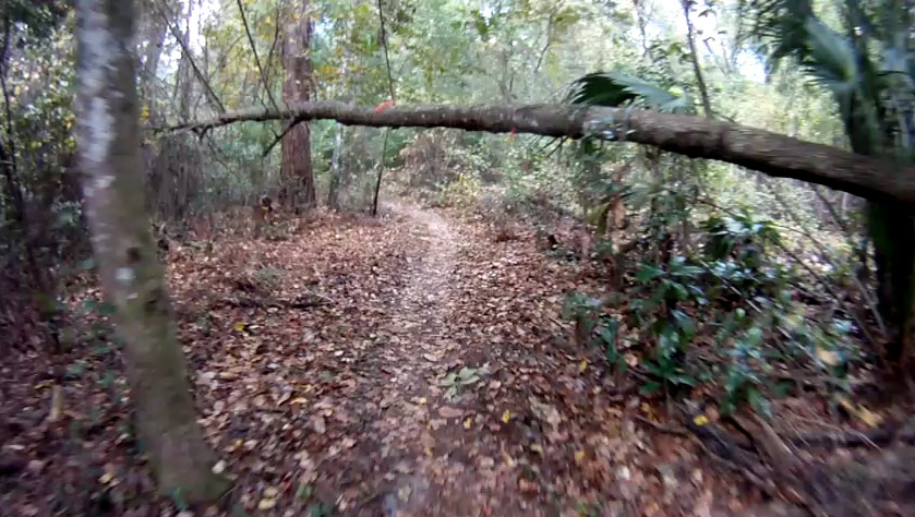
We stormed to the trail head, got our punch card and bolted into the trails. It was a surprise to see that the technical trail was that of a BMXer's dream (for a FL adventure race). There was plenty of dips, curves, bowls, lips, bridges, trees and accidents waiting to happen. The instructions were to ride the entire trail in the proper order (upper half of blue->red->yellow->lower half of blue), while collecting obviously placed CPs (obvious because of how important it was to using your immediately sight, or else you fell off cliffs).

I thoroughly enjoyed this course. It was the most intense workout of the race, pounding the abs very well. Roda told me this was the first time he had done anything like this. I'll let the video (small segment of the entire 55min course) show our experience here. The video doesn't do justice on showcasing the changes in elevation as I remembered it though.


Chris was swearing every curse word invented on the way back for losing the punch card. I didn't really care much. We both had accidents and made mistakes that costed us significant time throughout the race. I think at this point, I had fully accepted we were not competitive whatsoever. I still enjoyed everything else of the race and absorbed the newbie learning experience.
Eating is a factor that I focused on this race. One of Ron Eaglin's blog mentioned that you may burn 10,000 calories in a 12hr race. I calorie loaded with all the Thanksgiving I could eat for the past couple days. I made sure I got some kind of food at the control points or at the transition areas. But despite eating more than I had in my other two races, my stomach still rumbled of hunger after 15minutes of consuming anything.
Bike 3
The start of the 3rd bike leg had us heading up a path alongside a railroad. It took us two attempts before heading up the right road. We failed quickly though and didn't lose much time. Once on the right path, it was straight forward to finding the next transition area, Heartland TA. This place was like a ranch of inhospitable wilderness, of overgrown grass and scattered baby cacti. This was the area that you dreaded seeing sugar sand that kept speeds slow and thighs burning, if not cramping.


CP23 was easy to get to, but then I realized the map was of a Google satellite image, meaning there were probably very faint trails that were covered by treetops. Pangea marked the direct trails on our map, but we had to anticipate there could be more, unmarked. The trail to CP24 was sugar sand madness, accompanied with nonstop up and down small hills. We were going so slow, it gave me time to measure our compass bearing, turn by turn to confirm positioning. Heading out, we both popped several potassium pills to try to alleviate leg cramps.


As we headed back to Heart Island TA, we discussed how this was the worst bike trail ever. If you weren't on sugar sand, you were on the side trails where spurs could pop a tire (in fact, both of us ended up with a flat tire back at the main TA). Horse shit scattered a segment of the trails. Our asses were so far in pain, I'm not sure it made much of a difference how much more it got pounded by the bumpy roads back. There was an hour 15min left, so we called off Foot 2 portion. It would take about 30minutes to head back, which left barely any time for CP hunting. Looking at race results, it took us 33min to get to Heartland TA and only 24min heading back--incredible.
Oh! Another thing...Greg came to us at this point and told us that another team had found our lost punch card and returned it for us. Saviors! Whatever team that was, THANK YOU for recovering 5pts for us! We owe you one.
Foot 2
At the main TA, we had 50min left. I calculated it would be a mile's jog to collect one control point. Roda was a in a world of ache at this hour. If anything, we could walk a mile in 45min, but not sure how long it'll take to attack and find a CP. About 20minutes into the trek, we called it off and returned back. We did not want to risk losing a point or two to find another point, due to finishing late.


Conclusion
The Turkey Burn put us through a multitude of conditions--night racing, mountain bike technical course, paddling for 5hrs+, sugar sand biking, smooth roads, strange tall cotton grassy fields with cacti, etc. It was an extremely challenging course, and I have a great appreciation for the course designer and event organizers.


Pre-Race Article (Canyoneros are mentioned in there)
http://www.pangeaadventureracing.com/news-details/items/preview-turkey-burn-ar-2011
Race Details and Results
http://www.pangeaadventureracing.com/event-details/events/2011-turkey-burn-ar
Race Photos
http://www.facebook.com/media/set/?set=a.10150393363306375.352042.108723771374&type=3
http://www.facebook.com/media/set/?set=a.10150397881381375.352592.108723771374&type=1
Pangea Adventure Racing Facebook
http://www.facebook.com/pangeaadventureracing
(glass-smooth vastness of Lake Woodruff in the early morning)

It turned out our 'shadowy tree' identification proved correct. The closer we got, the more activity we saw of boats and other canoes there. We rounded the peninsula that shielded CP11 and spent about 30min looking for it. There was no channel along the west side of the water. Up and down we went, searching for anything that resembled a channel to shoot our canoes into. We went shallowly into a handful of flukes and could not find this. We finally called it off, and looking at the time left, called off CP12 as well.
The return route contained CP's 13-16. The sun had risen higher at this point. We were paddling east with the sun glaring into our face and the winds blowing hard. There were underwater vegetation in some areas that added friction to our speed. We felt everything that slowed us one bit. Our backs were fried, but after repetitively paddling left, right, left, right for almost 6hrs, it had gotten so used to it that our brains weren't registering the fatigue anymore. Other than that, there was no drama to finding the rest of the water CPs. We were dead last returning the canoes and internally screaming to get the heck out of there. At least we beat the declared 11:30am cutoff point by a couple dozen minutes...eh heh.
(the return route - hours of paddling, winds roaring, sun shining in our faces)

(boats speeding by, sending waves at us)

(Boat TA)

(Roda giving the canoe the moon)

Bike 2 - Chuck Lennon Trail Head
(bike 2 Chuck Lennon Trail Head course map)

We walked back to the main transition area to proceed to Chuck Lennon Trail Head. None of us could really figure out where the road leading to it was, and after my failed attempt to go down the wrong path in the parking lot, we admittedly asked the man at the information booth where it was. We were getting pretty desperate at this point.
We stormed to the trail head, got our punch card and bolted into the trails. It was a surprise to see that the technical trail was that of a BMXer's dream (for a FL adventure race). There was plenty of dips, curves, bowls, lips, bridges, trees and accidents waiting to happen. The instructions were to ride the entire trail in the proper order (upper half of blue->red->yellow->lower half of blue), while collecting obviously placed CPs (obvious because of how important it was to using your immediately sight, or else you fell off cliffs).

I thoroughly enjoyed this course. It was the most intense workout of the race, pounding the abs very well. Roda told me this was the first time he had done anything like this. I'll let the video (small segment of the entire 55min course) show our experience here. The video doesn't do justice on showcasing the changes in elevation as I remembered it though.
(video of bike segment, where I ran into 3 trees in a 5min span)
Upon arriving at the last control point, Roda realized he had lost the punch card due to not zipping up his map holder! He punched the last control point on the map and we headed out, losing 5pts and taking an extra 1pt penalty for losing the punch card. There was no way we could back track and find that punch card.
(dozens and dozens of drops, with a tropical rainforest-like environment)


(plowing down entire trees on uphills :p)

(booby traps, ready to take your head, along the path)


(good thing the Canyoneros didn't wreck into these; they would have been knocked 20ft away :))

(gate keepers of Chuck Lennon Trail)

Chris was swearing every curse word invented on the way back for losing the punch card. I didn't really care much. We both had accidents and made mistakes that costed us significant time throughout the race. I think at this point, I had fully accepted we were not competitive whatsoever. I still enjoyed everything else of the race and absorbed the newbie learning experience.
Eating is a factor that I focused on this race. One of Ron Eaglin's blog mentioned that you may burn 10,000 calories in a 12hr race. I calorie loaded with all the Thanksgiving I could eat for the past couple days. I made sure I got some kind of food at the control points or at the transition areas. But despite eating more than I had in my other two races, my stomach still rumbled of hunger after 15minutes of consuming anything.
Bike 3
The start of the 3rd bike leg had us heading up a path alongside a railroad. It took us two attempts before heading up the right road. We failed quickly though and didn't lose much time. Once on the right path, it was straight forward to finding the next transition area, Heartland TA. This place was like a ranch of inhospitable wilderness, of overgrown grass and scattered baby cacti. This was the area that you dreaded seeing sugar sand that kept speeds slow and thighs burning, if not cramping.
(bike 3 and foot 3 map)

(sugar sanded bike trails--the worst)

CP23 was easy to get to, but then I realized the map was of a Google satellite image, meaning there were probably very faint trails that were covered by treetops. Pangea marked the direct trails on our map, but we had to anticipate there could be more, unmarked. The trail to CP24 was sugar sand madness, accompanied with nonstop up and down small hills. We were going so slow, it gave me time to measure our compass bearing, turn by turn to confirm positioning. Heading out, we both popped several potassium pills to try to alleviate leg cramps.
(mosquito swarms, eaten alive by Roda)

Reviewing the map again, we noticed CP25 was the furthest. We agreed to gather the closest ones first, in case the conditions got so bad that we had to call off some CPs. CP27 was easy to find. CP26 took several attempts at attacking in to find this vegetation boundary. Being new to this, we didn't exactly know what 'vegetation boundary' visually looked like. There was no scale to measure distance and I had forgotten what Greg said at the race meeting with regards to what the scale on this map was, so we took the old fashion approach of constantly moving along, searching, repeating, move up some more, search again--very Canyonero-like :D. I finally found something that best resembled 'vegetation boundary' and then focused all my searching efforts there. Roda backed me up by searching more ahead. I finally found the control point with a missing punch, so I made sure to film this on my GoPro. CP25 was an easy find. The clue "watering trough" was actually a mediocre bucket of water.
(tall cotton/wheat-like grass field)


(vegetation boundary of smaller plants, next to tall dark green trees near path in map)

(CP26 with missing punch)

(video of bumpy paved roads)
Foot 2
At the main TA, we had 50min left. I calculated it would be a mile's jog to collect one control point. Roda was a in a world of ache at this hour. If anything, we could walk a mile in 45min, but not sure how long it'll take to attack and find a CP. About 20minutes into the trek, we called it off and returned back. We did not want to risk losing a point or two to find another point, due to finishing late.
(jungles of the trek portion)

(swamps on either side)

(bridges)

(plenty of jutting roots)

(paved roads, full of palmettos on each side)

The Turkey Burn put us through a multitude of conditions--night racing, mountain bike technical course, paddling for 5hrs+, sugar sand biking, smooth roads, strange tall cotton grassy fields with cacti, etc. It was an extremely challenging course, and I have a great appreciation for the course designer and event organizers.
(main TA, place of refueling)

In the end, if you look at our scores, you can say we suck, being in dead last place, but dammit, Canyoneros have some thick heads and stubborn determination and will not give up this easily...see you next year.
(this is me subconsciously knowing ahead of time, that we had spent almost 6hrs on a canoe)

Pre-Race Article (Canyoneros are mentioned in there)
http://www.pangeaadventureracing.com/news-details/items/preview-turkey-burn-ar-2011
Race Details and Results
http://www.pangeaadventureracing.com/event-details/events/2011-turkey-burn-ar
Race Photos
http://www.facebook.com/media/set/?set=a.10150393363306375.352042.108723771374&type=3
http://www.facebook.com/media/set/?set=a.10150397881381375.352592.108723771374&type=1
Pangea Adventure Racing Facebook
http://www.facebook.com/pangeaadventureracing


