Saturday, December 14, 2013

Pangea Christmas AR, Elite 3.5hr


This race brought out all the original Canyoneros and was agreed to be one of the funnest race we've had together.  Everyone was in high spirits as they made their return to adventure racing in the Christmas AR.  The lineup included (left to right) Brian Ruth, Russell Barton, Greg Watson, Hien Nguyen (me), Juan Chavez, and Amber Punga.


Foot
The race staggered the teams 30 seconds at a time, so we all waited for each other on route to the first CP before racing it as a giant group.  "Flyin" Brian shot out the gates after a few cups of coffee and a Redbull.  With guns blazing, he instantly became my go-to man for punching controls for the whole group.  Juan immediately rolled an ankle five minutes in while running over the boar-dug ground.


I measured out just about every distance we would cover on this leg and navigation proved flawless.  We ran the route clockwise, slower than our normal race speed considering the size of the group, but the route choice and pinpoint accuracy ultimately gave us the third fastest time for this leg.  Here's our recorded GPS route on this leg.

nice shortcut from CP2 back onto the Yellow trail

CP3 had a challenging attack point, but if you counted paces and kept an eye out for a south bend in the trail, it was noticeable.  You also had to look at the Google maps provided before the race to know that there are some distinctive features at CP3, namely the open field it bordered.  Heading out of the last CP1, we bushwhacked directly south to get out on flatter, more direct road back to the Main TA.


Bike
There were numerous options to be strategized on bike.  Some teams rode all the way to St. Nicholas Ave for CP6 first, maximizing speed.  One team I heard went up the white trail to get CP7, 6, and then the rest, thereby cutting distance down.


I had planned a route that didn't require bikewhacking at first, going counter-clockwise, and staying on the red trail until CP6.  Two reasons...1) CP8 looked like it was easier to locate an attack point from the east, 2) I wasn't sure if the trail at point B existed in real life.  Later on, however, with the trail conditions putting a pounding on the teams, I knew we had to cut some distance out.


everyone feasting at one of the controls

CP8 ended up being found by an easily identifiable marsh.  We had been having so much success thus far, so upon leaving there, I measured what it would take to bushwhack onto the white trail to get CP7.  Greg and I were the strongest biking team out of the three teams, so we stormed ahead to identify this point at which we would cut over.  We rode about 1km, slowed down, observed, and waited for the trail to bend north.  As soon as it did, the other guys caught up and we slithered into the forest.  The trails can be faint out in Tosohatchee, but with 6 set of eyes, we were able to see anything.


CP10 was also found in similar group strategy as before.  Greg and I bolted ahead, located the control, while the other two teams caught up.  We had no mistakes on this entire bike leg.


Canoe

map of canoe section

A short bike ride to the Boat TA started this leg off.  We had to trek through some nasty mud before picking up our boats near the river.

We almost blew by CP12 due to how well hidden the control was.  We DID blow by CP13 due to map scale (I'm not used to paddling so short before the next CP), but decided to pick it up on the way out.


Map scale again got me, as we docked our boats way too soon to find CP14 (point A on the map).  It was my only mistake on the entire course that costed at least 5 minutes, but Brian and the search party backed me up well with their foraging technique of hunting.  In fact, in the past, Brian's been known to uncannily sniff the CPs out to make up for my mistakes in navigation.  I had my shoes suctioned out five times in some of the muck we went through on this leg.

spearing other canoes in spontaneous battles of jousting is a sign of canoe dominance.  more points for t-boning

From CP14, I shot a direct bearing to CP15, counted the prescribed paces and stopped for them to fan out. However, "The Barton" was first to realize the control was immediately to my right.  On our way there, the scene was really surreal (pic below).  The brown line you see is not the horizon.  The water actually rises up to that line and caused a permanent stain on every tree.

this is what Christmas looks like in the swamps of Christmas, FL

Brian lost steam here as his legs gave way to paralyzing cramps - awesome face!

Amber pulling the canoe by herself with mighty girl power

There was a 250m canoe portage we had to do from the edge of the river to the main road.  Here, Brian's legs locked up to cramps, and we ended up towing him back to the Main TA and finished 6th out of 33 overall!

Big props to team We Blame Javan for taking third overall.  We'll be racing with them on the next two races, including the epic 72hr Sea to Sea AR, under the name "We Blame Pangea"!

Saturday, November 30, 2013

Pangea - Turkey Burn AR, Elite 12hr


A slab of wood joined with two raw stumps of log (pic above) represents the true essence of what it is to adventure race.  There are no bells or shiny metal on this.  Symbolically engraved into this primitive trophy are lifelong memories of wild adventures we have experienced--chased by a mountain man with a shotgun, bushwhacked the undergrowth on hands and knees, charged at by a bullcapsized in the rapids of Georgia, and even falling off a cliff today, just to name a few.

Canyoneros like aim for the sky but unspokenly know most of our visions are too lofty to get letdown on if not achieved.  The results of this year's 2013 Championship Turkey Burn AR was the pinnacle of a full season's long worth of growth for our 2+ yr team.  We started from scratch, literally at the very bottom of the pile a couple years ago, not knowing which is the front on a canoe, to a team who has taken just placed first in the Open division championships.  It was a race that finally fulfilled one of our desired goals, our proudest moment yet!

The Turkey Burn AR this year was billed to be more urban than usual, starting in civilization at the University of Central Florida (instead of the remote wilderness).  We spent about 1½hrs on campus, total, in a 12hr long race that started at 4am--not your typical urban race :)


Prologue
It was dark, yet bright under the parking lights of the campus lot, misty, yet warmer in temperatures for a race at this time of the year.  We piled at the start and were spontaneously told to run up 3 flights of stairs at a nearby garage building and go down the far end, only to run another 250m to another nearby building and back.


Bike 1
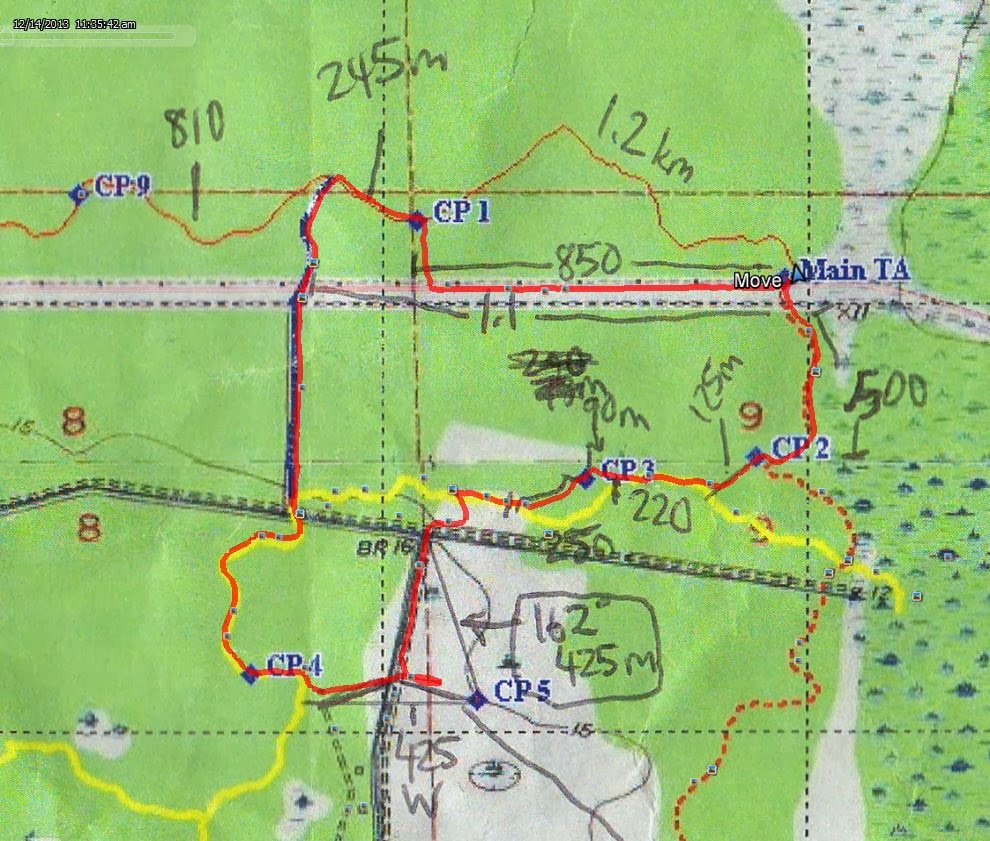
We were given orienteering maps immediately afterwards, on-the-fly, to head out on this leg of the race.  Four controls were plotted around campus.  As large as UCF's campus may appear to people who visit it, it is highly compressed with a dense collection of features, such as buildings and sidewalks, more than our regular adventure racing maps.  You had to really know the campus well to move fast in the dark, which we didn't.  We took a newbie approach of latching onto another team who seemed to know what they were doing for the first two controls, only to maintain speed.


However, on the 3rd control, we had to slow things down to figure out where we were.  As I calibrated my bearings, we headed towards CP3 and got immediately derailed into a wrong trail.  Teams came towards us and away in multiple directions.  This is the control that really messed many teams up.  At this point, I really wanted to zone the crowd out, go back to the beginning, identify the mapped lake and start that control over.  We did and messed up again by following an unmapped trail all the way to the south of the lake.  Ughh...alright, back to basics.  "Go back to a known spot and measure precisely, one turn at a time.  From there on out, the fundamentals got us the final two controls flawlessly.  Up next was a 7.5km bike ride through the city to a boat launch.


Boat 1
Our strategy for the race was to "Go slow to be fast".  It's a motto my mentors taught me during the days I raced cars.  It means don't overdrive or fashionably slide a car around turns because you will lose more time than you think you make up for in speed and tire squeal.  In adventure racing, to last a 12hr race well, you have to throttle that energy back.  Going full bore means your brain shuts down and you make mistakes or get lost, which translates into longer distances that produce longer times.  This isn't a race where you follow a road.  This is race where you make up your own routes, even if it means swimming across swamps.


Dave Brault, the course designer, advised at race start that the first three controls on this part of the race were going to be difficult to paddle to.  I had that hunch before the race when I saw how close those controls were.  It didn't intimidate us, as we had our sights on clearing the entire course at that point.


We went for CP7 first, which was pretty easy.  The next two were slow-going.  When we got to the river split, there were over half a dozen canoes beached on the shore, where teams left them to go on foot.  We did the same, tore down fields of palmettos, and trucked across shallow areas of the river.  There was even one control where we tight-roped across a suspended fallen tree over water to reach it.  It was great.

I had measured some distances between controls ahead of time on the river so that we could run the stopwatch and keep track of pace.  However, the river was quite twisty and had many logs to block and slow you down that that technique did not work so well, but I was still able to keep track of our position, turn-by-turn.  We were alone for a while on that river until last year's reigning champs, Good'Nuff, blazed by us so silently and what appeared effortlessly.  Their transitions in and out of punching their cards was like a ping pong.  It was incredible and inspired us to paddle even faster.


Foot 1
Pulling up to the Barr TA (transition area), we carried our canoes up a cliff before switching to the running section.  We were told by the staff that we were in the middle of the pack at that point.  Honestly, hearing that eased some race pressure.  If you're at the front of the pack, the race urgency tickles you to do whatever you can do keep that lead.  When you're in the middle, well...the teams ahead just prepared better than you.  But 12hrs is like three or four marathons.  You can be fast at first but gas out terribly in the middle of the race.  Or you could have skipped several controls and be ahead on route, but not on scoring.  You never know what happens at the end, especially the longer the race gets.


A new map was given to us here.  We punched CP12 easily.  CP13 looked really tricky on map.  It was really tricky in real life too.  Nate and I executed the full plan by measuring the distance from the closest intersection, counted running paces until the trail bent, and shot a bearing to the north.  We never saw that faintly mapped trail, but kept with the plan and when hope was running out, Nate spotted it in the distance.

the dewy morning

At CP14, we ran into our next year's 72hr race teammates, We Blame Javan, and found the next six controls together.  It was a long jog to CP21 before we got back to the Barr TA.

our GPS route with color-coded pacing


Boat 2
From Barr TA, we carried our boats back into water to continue the race.  For some unknown reason, my GoPro camera beeped to change batteries after only recording for 1.5hrs.  I have the extended battery pack, which normally provides me 4.5hrs of record time before I need to change out two sets of batteries.  Upon fumbling to change them out on the boat traveling around a log filled corner of the river, I accidentally dismantled the case hinge and could not figure out how to piece it back together.  It also caused us to get log-jammed, so from there on out, the GoPro was out of commission.  Such a shame, because not five minutes later, the following happened, which would have provided epic Canyonero footage:

At CP26, the map showed a channel that branched off the main river.  It appeared you could just paddle your way into the channel.  In real life, the opening of the channel was closed shut, so we banked our canoe at the opening (point A).  This made for some stagnant water that just sat there, brewing up some foul smelling, potentially gator-laden, bacterial waters.


I took a gamble, followed Kayla from Team Super Frogs, and chose to run up the east bank enroute to the control.  At point B, she spots the control and tells me "crap! we're on the wrong side of the water," and proceeds to turn back.


The race urgency is funny sometimes, but only if you survive.  I took one look at the river, which was about 15-20m across, and started challenging myself like a fool (aka, Canyonero).  Yes, I had thoughts of swimming across this nasty dark water.  I grabbed a long, fallen palmetto branch and jabbed into the water at the edge of the channel.  It was maybe 2ft deep....not bad.  All judgment left my mind as I cautiously stepped in and went forward.  It got deeper and deeper.  The deeper it got, the softer the ground became, and the more my shoes got sucked into the mud that marinated at the bottom.  I was about a third of the way across, chest deep, and nauseated by the shit-smelling muck I was in, when I deemed "point of no return" and lunged in.  Suddenly there was no bottom.  All I felt was warm, slimy mud around my legs.  Thoughts of being sucked down and paralyzed in the quicksand that burped from beneath crossed my mind amidst a mini-panic...that and alligators :)  To my relief, the life vest I was wearing suspended me back up and I swam myself across to the other side (GPS route shown above).  Team Super Frogs trekked behind me and even commented on how badly I smelled, but gave me props in the spirit of adventure!


Bike 2
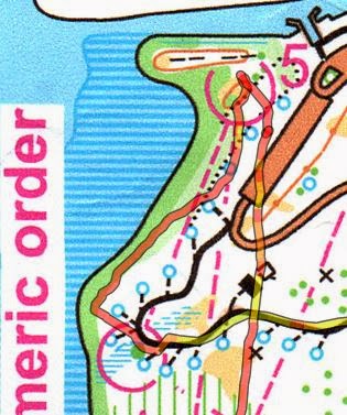
Eventually, we paddled to a bridge overpass, where the Snow TA was located.  Some 6hrs in, we spent some time refueling at the first location to provide us with fresh water.  This section had us following a set of bike trails at Snow Hill.  One of the controls had a clue of "ditch of doom" to give us a warning of what we were in for.  Luckily, we were close to Team Super Frogs, who seemed to know this area much better than we did.  There were several trails and options to choose from and we were at a lost at first.  We relied on them for the first 10 or 15minutes, but from then on, decided it was better to understand our position and go solo.

map of Snow Hill single track biking trails

Somehow at CP34, we poked out of a trail much south of its control (the hill) and just left it.  At CP36, we realized we were missing one and this became the first and only control we couldn't find, although, we just about biked right over it.  There was a period of about 10minutes where we backtracked to try to find it, but we had no luck and called it.

This is also the section Nate suffered the "bike seat up the ass" incident.  There was a moment where a root halted his bike and the bike seat rammed up his tail bone, probably to the point it's broken (update 12/3/13: confirmed broken tail bone).


Bike 3
Starting at Snow TA, we took the blue route to a Bridge TA for the start of a running segment.  This route was filled with the dreaded sugar sand.


Foot 2
We were back at Little Big Econ, using the orienteering maps for this leg.  We found all of them rather effortlessly, but I have to say, CP44 was placed for the really elite teams.  The only way I could figure out a plan to find it was to follow the ditch that intersected the trail (luckily there was a bridge over it), count about 125m in and locate the marsh south of there.  It was slow going through the ditch, so one step was not really 1m.  We ended up shooting south out of the ditch too soon, but Nate was sharp enough to identify a mapped clearing, which I used to shoot a bearing towards the marsh.  It was done very well.


Bike 4
The previous foot section took us back to Bridge TA, where we copied controls and descriptions from a master map to our own maps.  This was an area of technical biking trails with lots of tree roots.  I have always known how tough it could be to navigate technical biking trails.  There are many reasons.  One is that the trails are usually very twisty, as to make measuring distances on map difficult.  Another is that while biking it, 75% of your focus is to traverse the terrain safely.  Third, the mapped area was only 1x3", which means the mapped route did not have the small intricacies of turns.  And worst, the mapped routes did not show every trail or intersection.  With that said, I'm always needing to confirm direction by holding the compass out in front of me, riding with one arm, observing the map and moving a marker across that map.  The controls were not simply along the trail route here...no...you had to really find your attack points, stop and hunt.

So as I was making trial and error decisions on how to navigate this route and going back and forth, Nate's painful broken bone was provoking silent thoughts of ways to choke me afterwards :)  I deceivingly kept him hopeful by promising it was "only 100m" ahead, or backward.

Karma was dished out to me while I biked along a curve that peaked above a river.  The path was extremely close to a cliff on the right, and there was a tree to the left of the single-track trail.  I did not want to fall off the cliff, so I stayed overly cautious by hugging the left side...a little too much.  I smacked the tree with my shoulder and bounced immediately away from it, flying down the cliff and into the abyss below me.  Life flashed before my eyes as I accepted my fate within a span of half a second.  It sure seemed like it was done in slow-mo though.  Nate, who was behind me, recalled my bike flipping over and over down the side, while I somehow bounced off the sides, landed on my feet, and amazingly halted the wipe-out about 20ft down.  Another epic GoPro moment forever lost!

I must have had four attempts at trying to find CP50 before calling it.  Then, once we found CP51, I had my bearings straight again, and was able to measure precisely our way back to CP50.

Even the easiest CP52 alluded us!  We biked all the way to the end of the trail, found a gate and backtracked "90m from end of trail".  Nothing.  So as we biked back to the gate for the third time, a trail appeared out of nowhere to the left of the gate.  We took it and found the CP.

The 12-13km bike ride back to UCF campus was uneventful.  We used that time to strategize our last few controls since time was running out.

Upon reviewing the times for this segment from other teams, I now don't feel so bad about losing so much time here.


Foot 3
With 45minutes left, we headed out on the last foot section to find 4 out of 7 controls on campus.  My laziness of not using the compass had us headed in the wrong direction for the first 8 minutes.  Once I figured out where we were, we backtracked and stuck to our original game plan.  Navigation was quick and easy here.  Nate, who's the stronger runner, helped me out tremendously by taking the brunt of the running leg work.  Halfway through, we calculated we could grab one more control than we planned and did.  We came to the finish with just about 8 minutes to spare before time ran out, completing this leg by finding 5 out of 7, leaving two on the field due to time.  Overall, we collected 56 out of 59 control points, the most ever in any race we have participated in!

We knew we had given it our all and raced a solid race with no fatal setbacks.  We were proud having done so much better than last year and felt the huge improvement we pushed for this season.  We ended up winning the Open division title, a glorious end to year we almost broke down physically to training and accidents.


Conclusion

Special thanks goes to John Sheriff and his team for graciously giving us their prized wooden trophy, so Nate and I would both have one, as we tried to figure out how to chop ours in half :D

It was a great race designed by Dave Brault and Jim Feudner.  There were many unique elements and great experiences in this race, including a whopping 10 segments of activity.  We heard many other teams' incredible stories, and even a shocking one that involved a racer...a girl...getting struck by a motorcycle, yet still prevailing to finish second overall!  That just about beats all my crazy tales.

Saturday, November 16, 2013

R.I.P. - Destroyed AR Equipment

Adventure racing puts a hell of a beating on the equipment.  There aren't very many items that withstand constant use in AR.  For the ones that do, I applaud.  Canyoneros' brute strength has destroyed the following items during our ~4-5yr career.  May you rest in peace...

Hien's List
  1. Bike 1
    • aluminum frame
    • bottom bracket
    • crankset
    • a pair of wheelsets
    • rear QR skewer
    • a dozen tire tubes
    • a set of brake pads
    • plastic pedals
    • derailleur hanger
    • Stans Crest 29er wheel rim (bent into a potato chip shape)
    • (2) helmets
  2. entire 10'x10' canopy tent
  3. (2) Nite Izes military-grade flashlights
  4. (2) medium-sized Sealline map cases
  5. (2) bike map holder
  6. 2 Nite Ize carbon fiber pens
  7. a Camelbak bite valve
  8. mapwheel
  9. (2) waterproof phone cases
  10. a pair of $70 AR pants (lasted 2 events)
  11. Suunto M-3G compass (seized up on first use)
  12. (2) head lamps
  13. 128gb MicroSD card
Nate's List
  1. Bike
    • An entire wheel replaced
    • (2) entire drivetrain incl cables replaced (cassette, crankset, chain)
    • another rear deraileur
    • rear wheel hub
    • Two chains
    • 1 bike pedometer
    • two bike pedometer magnets
    • a helmet
  2. An entire camelbak
  3. 1 camelbak bite valve
  4. 1 compass
  5. 2 pairs of gloves
  6. Countless race shirts
  7. 1 pair columbia trousers
  8. 2 pairs shoes
  9. 4 pairs compression stockings
  10. Several pairs running socks
  11. A kayak paddle 
  12. 1 water bottle
  13. An iPhone 3gs (water damaged)
  14. A waterproof (yeah right) torch
  15. A headlamp
Greg's List
  1. a set of gloves
  2. a set of shoes
  3. a set of kayak paddles
Russell Barton
  1. an Iphone

Saturday, October 19, 2013

Pangea - Lighterknot AR, Elite 8hr


Driving home, we usually give out our own awards to best adventures we experienced during the race.  To this date, no bushwhack has ever stopped us from blazing a trail of our own.  Today's direct bike bushwhack from WP2 to CP23 is now the new reigning champ of our "Worst Bushwhack Ever" award.  That 500m length of hell dethroned a previous 100m bushwhack we crossed stomach-high rotten swamp while getting cut up by vines of thorn.  Today, we have cuts and scrapes running up both of our entire arms, neck and face that give us the appearance of battle warriors!  To top the look off, my arms swelled up like Danny Trejo's lumpy face, as my allergic reactions tried to deal with it.

Foot 1

To start, we immediately shot a bearing of 300 degrees, as pre-measured in the morning.  While traveling through the vegetation presented, I must have run over 50 saucer-like spider web contraptions.  Once we hit the wall of trees, many teams converged and hunted for this CP6.  It ended up being much more north than we had measured because the Main TA plot may not have been in the most precise area.  We ended up finding that with the help of other teams nearby.

the morning dew

CP7 was pretty easy--identify the trail intersection before cutting into the wooded pine tree forest about 40m north of it.

race map

CP8 gave us some trouble.  We didn't count paces and there were multiple trails and outlets there so we poked into a couple of areas before running into a 3-way trail intersection that I could relate to on the map.  Again, 8 was found with some help of other teams.


Going down to the Boat TA, I mistakenly took a trail heading south, but quickly corrected.  I should have taken note of its existence since it would come back to haunt me later.

Single Man Canoe Mini Game

In the middle of the first foot section, we ran by the Boat TA.  Nate was chosen to paddle about 30m out to a set of bells across the river and ring it.  It was his first time to paddle a canoe by himself--with a canoe paddle, not a double-sided kayak paddle.  I'm pretty sure the grin on his face was just him showing off doing a couple spin tricks on the way out and back, haha.

Nate, paddling a couple of 360 degree spins :)

Bike 1

We took advantage of the paved roads and pedaled fast and hard.  Despite doing so, team BikeWorks and RinkSide Sports were having their own competition ahead of us.  We were amazed by their speed to say the least.  No trouble here, but I'll give due respect to the teams ahead of us for finding the CPs for us!

this is where they grow cabbage patches

This is the segment where I started feeling twitches in my quads...no good!

We were given wristbands at pre-race so every team member had to punch various controls.  Nate saved me several times by reminding me I had to punch my wristband, because I totally forgot about those extra instructions.

Boat

I never thought I'd ever write such a thing, but we cleared the entire boat boat section with absolutely no issues.  Every length was measured out and backed by a stopwatch, and every turn was tracked.  I don't know what else to say!  We had the 2nd fastest time here, only beaten by Dash's team by two minutes, who we deemed were not humans :) (they won first overall by about an hour)

water was glass smooth

To split from the two teams ahead of us, we decided to head east on this river first.  We don't like racing with teams around us.  It doesn't allow us to learn for ourselves, and the race pressure frequently forces us to focus on the competition rather than the navigation.  A mistake by the leading team will punish following teams, but you can also say their success could also be yours.


This is the segment where Nate started feeling the beginning effects of overheating...no good!  He was proactive about cooling off with a wet towel on his head.  Who would give out first?  My leg cramps or his overheating??

Rodeo Challenge

These little comical games were pretty fun!  At the Main TA, Nate again was chosen to carry a sandbag around a sand-sinking donkey track.

EEEEE-AAAAW!

Bike 2

Seeing how close these controls were, I told Nate that I bet there would be no difference between this leg and the next trek.  I was absolutely correct--lots of swamp trekking and bushwhacking.

CP20, 21, 22 were easy and found with pinpoint precision.  It was CP23 that killed us (intro paragraph).  A 500m bushwhack with bikes took us a whopping 27 minutes to do!  Ouch.  Bushwhacking on a foot section is one thing, but when you have to drag a bike that is like a large billboard through some tightly grown bundles of tall, leathery, stemmed-plants that always want to wrap themselves around you, your 1mph bushwhacking speed cuts to about a ½mph!  It can even force you to go -½mph as you backtrack to find better ways forward!  The environment wasn't the worst, but the length and the body-beating amount of energy we spent traversing these 500 meters is why we voted it to win the "Worst Bushwhack Ever" award.  Imagine running for 4hrs and you have to squeeze in a 30min toughman contest before finishing 3 more hours of running.  And to top it off, these plants kicked up plumes of feathery pollen in the air for us to breath in the midst our exercise.  And oh...Nate stepped in a massive ant pile and received close to 50 bites!


So what went wrong?  On the map, there is this red line that appears to be a road to the west of where we started (blue arrow above).  However, when we followed this road down on the map, it crossed the river.  That can't be a road??  It must be a guideline or an illustration of a border, right?  No, there really was a road there :(  Had we known, we could have cut out 20 of those minutes :(


CP25 also gave us a little bit of trouble as well as the multiple teams around us.  We biked all the way to the gate without seeing any signs of a control.  As other teams saw us backtrack, they did the same.  We however, stopped about 100m back from the gate and cut into what appeared to be a faint connecting trail and silently found it :)

Foot 2

Again, that red mapped line did not have us considering the trail that headed straight down to CP27.  Instead, we took the long route near CP7 down.  We lost track of where we were on the trail around the marsh, so I had to take us back out to a known intersection to precisely count paces back to CP27.  It worked on second try, but at the cost of 30min just on this control.  This was our second major error that proved fatal.


From CP27, we shot a direct bearing to CP28 and found it fairly well.  From CP28, we again shot a direct bearing to CP29 and then headed back out on the hard packed dirt trail to find CP21 again.

what's the fun of adventure racing if you don't go through swamps?

There was a another series of bearing controls there at CP21.  So many times Nate would spot the control when I would start to run out of faith in my distances and bearings.

To get to CP32, we found the house nearby, bushwhacked about 20m north and ran along a hidden path.  It was then that we calculated how much time we needed to get back.  In my severely cramped state, we could not afford to find our last CP33, so we just trotted back to the Main TA.  Looks like my cramps beat Nate's overheating in the end, heh.


Rest in peace you Pangea shirt...I have no patience to pick these off

Saturday, October 12, 2013

FLO - Moss Park

Nate and I had trained here at Moss Park a year ago while our skills were still rather weak.  To stack the odds, I had recently tweaked my lower back (herniated disc injury years ago) and Nate was out drinking til 2am.  We like a little challenge ;)

As usual, we drove to the park, thinking of new tactics or experiments we could try.  To start, Nate would take the navigating role for the first time on a simpler orange course.

ORANGE COURSE

Here's the map and our GPS route overlaid on the Orange course.  Worthy to note is how skewed the map is compared our GPS route (esp. at CP6)


CP1
CP1 always takes a little bit of time, as we always adjust and feel out the scale of the map.  As soon as we located the pier, we knew CP1 was in the vicinity.  It was well hidden deep in a thicket.  It took us a bit to figure out the faint trails, but in hindsight, a straight line bushwhack from the start was the best route, considering how open that area was.


CP2
Nate used an intersection to shoot a direct bearing to CP2.  The ideal point would be point B, the bend in the trail.  The CP was only about 75m from the path, a distance where you can easily see far enough to know when to shoot in.  Point A just added a little bit more bushwhack, and even though it didn't take much more time, on a longer race with vast distances, it adds up proportionally.


CP3, 4, 5
CP3 and 4 were pinpointed exactly.  Going to 5, Nate decided to use the border of Lake Hart as a handrail.  I let him do whatever :)  We found it after identifying the nearby parking lot from the distance.  The faster route would have been to get back on the trail, run north to the parking lot about halfway down, and then shoot a bearing in from there.


CP6
(after adjusting the route to fit that area of the map correctly...) Nate's decision was to bushwhack a straight line from the bottom part of the parking lot to CP6.  This was a great idea since the forest was really open and you could save lots of time by cutting down the distance.  Despite the initial measurement being slightly off, we found nearby attack points to gauge where CP6 was.  Measuring compass bearings can be pretty tough on the fly.  The longer the distance, the more time you should put in how accurate of a measurement it is.  Even as little as 2 degrees off of a 500m bearing translates into being off path about 18m at the end.


Anyways, we attacked CP6 many times, even with nearby teams doing the same thing.  It wasn't until another team tipped us off, that we got it.  On GPS playback, the blue circle (above) shows where we punched the CP, which correctly corresponded to the number on our punch card.  This one was severely out of place!

CP7, 8
CP7, and 8 was too easy for Nate.  He did the right thing by planning out the next control, while I punched the card.

Great job Nate!


BLUE COURSE

CP1
Next up was me.  For CP1, I wanted to take the line indicated at the blue arrow (below).  Instead, the intersection (blue circled) crept up so fast that we just took the trail to the corner of the fence at CP1.


CP2
I recall measuring about 650m from the start of the causeway to the trail that ran down to CP2.  I counted probably 700m before we actually ran into it.  As we ran down, we counted another 300m or so before cutting in to find some distinct thickets.  Those were easy to see from the trail, however, there were a couple patches of them.  Luckily, we saw another set of people punching the right one.


CP3
From CP2 to 3, we shot a direct bearing.  The clue seemed like "series of ditches" or something like that.  Once we got there, luck again was on our side, as we found the control in the first ditch we ran into.  We saw another man literally carrying his team on his back--his baby--while orienteering.  Big props to him!

Heading out of CP3, I wanted to go straight south.  The orange areas on the map with vertical green lines "open land with undergrowth", which means there should be some form of slow running ability.  There was not, which is why you see us hook up north for a bit to see if there was a better opening to head south.  The blue arrow would have been the best route had I identified the high berm-like land feature better on the map.  There was an actual trail at the top of that berm, unmapped.


CP4, 5, 6
We made easy work out of CPs 4, 5, and 6 with direct bearings and pace counting.


CP7
Going out of CP6, however, I erroneously thought CP8 was next.  So I carved another bushwhack out for us thinking we had just punched CP7 (at CP6).  Uh oh...  As we committed, land features slowly did not add up to what I saw on map, but sometimes that happens.  I chalked it up to that.  We did find the trail we were looking for and the trail that headed east towards CP8.


As we kept pushing foward, we ran into a 4-way intersection that I was not expecting heading towards CP8.  Luckily I head counted paces from when we first hit trail.  Once I hit my numbers, I did not see any intersections in sight.  That's when I finally knew what happened.  I asked Nate if we had punched CP7, he confirmed no.  We immediately turned around, quickly found CP7, and headed out there with the same plan I had before.  Woo...that was 15minutes lost according to the GPS route.

This is the path I intended to use to take it out of CP7 and onto a trail (blue arrow below).


We made a kink in the line because the thorns there we so bad, Nate deemed it the worst bushwhack he had experienced.  He was leading the charge there with shorts, so I could understand (I had long pants which provided much more protection).  To add insult to injury, there was a stagnant low swamp we had to cross too.

So we poked out onto the trail at the exact spot I wanted, but cutting over looked too hairy.  We ran up some more and saw a break in the forest to cut through.

In hindsight, this is the route I would choose.  It minimizes the light green area (which could be the thorns), but allowed you not to cross swamp.  It also minimizes the distance under bushwhacking.  You never know though, until you go through it.  These are risks you take unless you know the park inside out.


CP8
CP8 was easy to navigate to.  We saw another team run there before we did, about 100m in front of us.  Their transition was piss poor slow though.  We steadily caught up, and without stopping, smoothly exited, while they were still waiting there measuring bearings and distances.  Both of us had two-man teams.  One man should punch, while the other figures a way out to the next.  It gives a seamless and quick transition.  It is little techniques like this that saves you a lot of time.  Imagine if you spent even just one minute at each control, measuring distances, for example.  On a course that has 13 control points, the team who can do this on the fly will finish a whopping 13minutes faster, which is significant.


CP9, 10, 11
At the intersection heading up to CP9, I couldn't identify the faintly mapped trail.  Fortunately, I had been counting paces and after 250m, I just had to cut into the forest look for this control.  It did not appear to be situated very far from the trail.  Bingo, easily found.  CP10 and 11 were easy to find while following the pond.


CP12
I wanted to attack CP12 purely with orienteering skills of "feeling the lay of the land out" by following the blue arrows (below).  After the trail bend, we ran up to the next intersection too fast that I only got to execute that plan half-way.  It worked and saved us some little distance.  This only works when the control is somewhat within visible distance from poking off the trail.  If that distance was, say 300m, I would definitely not risk taking that shortcut.  Accuracy is better on longer distances to a control, so running up to the closest known and mapped intersection is the way to go.


CP13
On the home stretch, I measured a bearing to CP13 and we cut across all types of roads towards it.


In the end, we completed two courses with a fatal error in each.  Better to make these errors during training than during races :)

On a side story, we had asked the volunteers to do a third course.  He said they wanted to wrap up, even after we promised a 15 minute white course completion time.  Blasphemy!  Canyoneros always do three or more courses!