Saturday, October 19, 2013

Pangea - Lighterknot AR, Elite 8hr


Driving home, we usually give out our own awards to best adventures we experienced during the race.  To this date, no bushwhack has ever stopped us from blazing a trail of our own.  Today's direct bike bushwhack from WP2 to CP23 is now the new reigning champ of our "Worst Bushwhack Ever" award.  That 500m length of hell dethroned a previous 100m bushwhack we crossed stomach-high rotten swamp while getting cut up by vines of thorn.  Today, we have cuts and scrapes running up both of our entire arms, neck and face that give us the appearance of battle warriors!  To top the look off, my arms swelled up like Danny Trejo's lumpy face, as my allergic reactions tried to deal with it.

Foot 1

To start, we immediately shot a bearing of 300 degrees, as pre-measured in the morning.  While traveling through the vegetation presented, I must have run over 50 saucer-like spider web contraptions.  Once we hit the wall of trees, many teams converged and hunted for this CP6.  It ended up being much more north than we had measured because the Main TA plot may not have been in the most precise area.  We ended up finding that with the help of other teams nearby.

the morning dew

CP7 was pretty easy--identify the trail intersection before cutting into the wooded pine tree forest about 40m north of it.
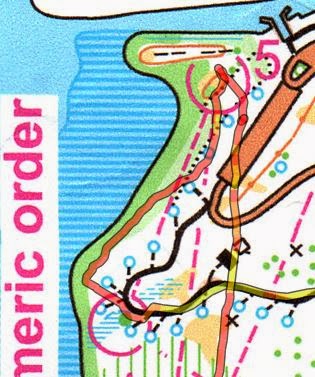
race map

CP8 gave us some trouble.  We didn't count paces and there were multiple trails and outlets there so we poked into a couple of areas before running into a 3-way trail intersection that I could relate to on the map.  Again, 8 was found with some help of other teams.


Going down to the Boat TA, I mistakenly took a trail heading south, but quickly corrected.  I should have taken note of its existence since it would come back to haunt me later.

Single Man Canoe Mini Game

In the middle of the first foot section, we ran by the Boat TA.  Nate was chosen to paddle about 30m out to a set of bells across the river and ring it.  It was his first time to paddle a canoe by himself--with a canoe paddle, not a double-sided kayak paddle.  I'm pretty sure the grin on his face was just him showing off doing a couple spin tricks on the way out and back, haha.

Nate, paddling a couple of 360 degree spins :)

Bike 1

We took advantage of the paved roads and pedaled fast and hard.  Despite doing so, team BikeWorks and RinkSide Sports were having their own competition ahead of us.  We were amazed by their speed to say the least.  No trouble here, but I'll give due respect to the teams ahead of us for finding the CPs for us!

this is where they grow cabbage patches

This is the segment where I started feeling twitches in my quads...no good!

We were given wristbands at pre-race so every team member had to punch various controls.  Nate saved me several times by reminding me I had to punch my wristband, because I totally forgot about those extra instructions.

Boat

I never thought I'd ever write such a thing, but we cleared the entire boat boat section with absolutely no issues.  Every length was measured out and backed by a stopwatch, and every turn was tracked.  I don't know what else to say!  We had the 2nd fastest time here, only beaten by Dash's team by two minutes, who we deemed were not humans :) (they won first overall by about an hour)

water was glass smooth

To split from the two teams ahead of us, we decided to head east on this river first.  We don't like racing with teams around us.  It doesn't allow us to learn for ourselves, and the race pressure frequently forces us to focus on the competition rather than the navigation.  A mistake by the leading team will punish following teams, but you can also say their success could also be yours.


This is the segment where Nate started feeling the beginning effects of overheating...no good!  He was proactive about cooling off with a wet towel on his head.  Who would give out first?  My leg cramps or his overheating??

Rodeo Challenge

These little comical games were pretty fun!  At the Main TA, Nate again was chosen to carry a sandbag around a sand-sinking donkey track.

EEEEE-AAAAW!

Bike 2

Seeing how close these controls were, I told Nate that I bet there would be no difference between this leg and the next trek.  I was absolutely correct--lots of swamp trekking and bushwhacking.

CP20, 21, 22 were easy and found with pinpoint precision.  It was CP23 that killed us (intro paragraph).  A 500m bushwhack with bikes took us a whopping 27 minutes to do!  Ouch.  Bushwhacking on a foot section is one thing, but when you have to drag a bike that is like a large billboard through some tightly grown bundles of tall, leathery, stemmed-plants that always want to wrap themselves around you, your 1mph bushwhacking speed cuts to about a ½mph!  It can even force you to go -½mph as you backtrack to find better ways forward!  The environment wasn't the worst, but the length and the body-beating amount of energy we spent traversing these 500 meters is why we voted it to win the "Worst Bushwhack Ever" award.  Imagine running for 4hrs and you have to squeeze in a 30min toughman contest before finishing 3 more hours of running.  And to top it off, these plants kicked up plumes of feathery pollen in the air for us to breath in the midst our exercise.  And oh...Nate stepped in a massive ant pile and received close to 50 bites!


So what went wrong?  On the map, there is this red line that appears to be a road to the west of where we started (blue arrow above).  However, when we followed this road down on the map, it crossed the river.  That can't be a road??  It must be a guideline or an illustration of a border, right?  No, there really was a road there :(  Had we known, we could have cut out 20 of those minutes :(


CP25 also gave us a little bit of trouble as well as the multiple teams around us.  We biked all the way to the gate without seeing any signs of a control.  As other teams saw us backtrack, they did the same.  We however, stopped about 100m back from the gate and cut into what appeared to be a faint connecting trail and silently found it :)

Foot 2

Again, that red mapped line did not have us considering the trail that headed straight down to CP27.  Instead, we took the long route near CP7 down.  We lost track of where we were on the trail around the marsh, so I had to take us back out to a known intersection to precisely count paces back to CP27.  It worked on second try, but at the cost of 30min just on this control.  This was our second major error that proved fatal.


From CP27, we shot a direct bearing to CP28 and found it fairly well.  From CP28, we again shot a direct bearing to CP29 and then headed back out on the hard packed dirt trail to find CP21 again.

what's the fun of adventure racing if you don't go through swamps?

There was a another series of bearing controls there at CP21.  So many times Nate would spot the control when I would start to run out of faith in my distances and bearings.

To get to CP32, we found the house nearby, bushwhacked about 20m north and ran along a hidden path.  It was then that we calculated how much time we needed to get back.  In my severely cramped state, we could not afford to find our last CP33, so we just trotted back to the Main TA.  Looks like my cramps beat Nate's overheating in the end, heh.


Rest in peace you Pangea shirt...I have no patience to pick these off

Saturday, October 12, 2013

FLO - Moss Park

Nate and I had trained here at Moss Park a year ago while our skills were still rather weak.  To stack the odds, I had recently tweaked my lower back (herniated disc injury years ago) and Nate was out drinking til 2am.  We like a little challenge ;)

As usual, we drove to the park, thinking of new tactics or experiments we could try.  To start, Nate would take the navigating role for the first time on a simpler orange course.

ORANGE COURSE

Here's the map and our GPS route overlaid on the Orange course.  Worthy to note is how skewed the map is compared our GPS route (esp. at CP6)


CP1
CP1 always takes a little bit of time, as we always adjust and feel out the scale of the map.  As soon as we located the pier, we knew CP1 was in the vicinity.  It was well hidden deep in a thicket.  It took us a bit to figure out the faint trails, but in hindsight, a straight line bushwhack from the start was the best route, considering how open that area was.


CP2
Nate used an intersection to shoot a direct bearing to CP2.  The ideal point would be point B, the bend in the trail.  The CP was only about 75m from the path, a distance where you can easily see far enough to know when to shoot in.  Point A just added a little bit more bushwhack, and even though it didn't take much more time, on a longer race with vast distances, it adds up proportionally.


CP3, 4, 5
CP3 and 4 were pinpointed exactly.  Going to 5, Nate decided to use the border of Lake Hart as a handrail.  I let him do whatever :)  We found it after identifying the nearby parking lot from the distance.  The faster route would have been to get back on the trail, run north to the parking lot about halfway down, and then shoot a bearing in from there.


CP6
(after adjusting the route to fit that area of the map correctly...) Nate's decision was to bushwhack a straight line from the bottom part of the parking lot to CP6.  This was a great idea since the forest was really open and you could save lots of time by cutting down the distance.  Despite the initial measurement being slightly off, we found nearby attack points to gauge where CP6 was.  Measuring compass bearings can be pretty tough on the fly.  The longer the distance, the more time you should put in how accurate of a measurement it is.  Even as little as 2 degrees off of a 500m bearing translates into being off path about 18m at the end.


Anyways, we attacked CP6 many times, even with nearby teams doing the same thing.  It wasn't until another team tipped us off, that we got it.  On GPS playback, the blue circle (above) shows where we punched the CP, which correctly corresponded to the number on our punch card.  This one was severely out of place!

CP7, 8
CP7, and 8 was too easy for Nate.  He did the right thing by planning out the next control, while I punched the card.

Great job Nate!


BLUE COURSE

CP1
Next up was me.  For CP1, I wanted to take the line indicated at the blue arrow (below).  Instead, the intersection (blue circled) crept up so fast that we just took the trail to the corner of the fence at CP1.


CP2
I recall measuring about 650m from the start of the causeway to the trail that ran down to CP2.  I counted probably 700m before we actually ran into it.  As we ran down, we counted another 300m or so before cutting in to find some distinct thickets.  Those were easy to see from the trail, however, there were a couple patches of them.  Luckily, we saw another set of people punching the right one.


CP3
From CP2 to 3, we shot a direct bearing.  The clue seemed like "series of ditches" or something like that.  Once we got there, luck again was on our side, as we found the control in the first ditch we ran into.  We saw another man literally carrying his team on his back--his baby--while orienteering.  Big props to him!

Heading out of CP3, I wanted to go straight south.  The orange areas on the map with vertical green lines "open land with undergrowth", which means there should be some form of slow running ability.  There was not, which is why you see us hook up north for a bit to see if there was a better opening to head south.  The blue arrow would have been the best route had I identified the high berm-like land feature better on the map.  There was an actual trail at the top of that berm, unmapped.


CP4, 5, 6
We made easy work out of CPs 4, 5, and 6 with direct bearings and pace counting.


CP7
Going out of CP6, however, I erroneously thought CP8 was next.  So I carved another bushwhack out for us thinking we had just punched CP7 (at CP6).  Uh oh...  As we committed, land features slowly did not add up to what I saw on map, but sometimes that happens.  I chalked it up to that.  We did find the trail we were looking for and the trail that headed east towards CP8.


As we kept pushing foward, we ran into a 4-way intersection that I was not expecting heading towards CP8.  Luckily I head counted paces from when we first hit trail.  Once I hit my numbers, I did not see any intersections in sight.  That's when I finally knew what happened.  I asked Nate if we had punched CP7, he confirmed no.  We immediately turned around, quickly found CP7, and headed out there with the same plan I had before.  Woo...that was 15minutes lost according to the GPS route.

This is the path I intended to use to take it out of CP7 and onto a trail (blue arrow below).


We made a kink in the line because the thorns there we so bad, Nate deemed it the worst bushwhack he had experienced.  He was leading the charge there with shorts, so I could understand (I had long pants which provided much more protection).  To add insult to injury, there was a stagnant low swamp we had to cross too.

So we poked out onto the trail at the exact spot I wanted, but cutting over looked too hairy.  We ran up some more and saw a break in the forest to cut through.

In hindsight, this is the route I would choose.  It minimizes the light green area (which could be the thorns), but allowed you not to cross swamp.  It also minimizes the distance under bushwhacking.  You never know though, until you go through it.  These are risks you take unless you know the park inside out.


CP8
CP8 was easy to navigate to.  We saw another team run there before we did, about 100m in front of us.  Their transition was piss poor slow though.  We steadily caught up, and without stopping, smoothly exited, while they were still waiting there measuring bearings and distances.  Both of us had two-man teams.  One man should punch, while the other figures a way out to the next.  It gives a seamless and quick transition.  It is little techniques like this that saves you a lot of time.  Imagine if you spent even just one minute at each control, measuring distances, for example.  On a course that has 13 control points, the team who can do this on the fly will finish a whopping 13minutes faster, which is significant.


CP9, 10, 11
At the intersection heading up to CP9, I couldn't identify the faintly mapped trail.  Fortunately, I had been counting paces and after 250m, I just had to cut into the forest look for this control.  It did not appear to be situated very far from the trail.  Bingo, easily found.  CP10 and 11 were easy to find while following the pond.


CP12
I wanted to attack CP12 purely with orienteering skills of "feeling the lay of the land out" by following the blue arrows (below).  After the trail bend, we ran up to the next intersection too fast that I only got to execute that plan half-way.  It worked and saved us some little distance.  This only works when the control is somewhat within visible distance from poking off the trail.  If that distance was, say 300m, I would definitely not risk taking that shortcut.  Accuracy is better on longer distances to a control, so running up to the closest known and mapped intersection is the way to go.


CP13
On the home stretch, I measured a bearing to CP13 and we cut across all types of roads towards it.


In the end, we completed two courses with a fatal error in each.  Better to make these errors during training than during races :)

On a side story, we had asked the volunteers to do a third course.  He said they wanted to wrap up, even after we promised a 15 minute white course completion time.  Blasphemy!  Canyoneros always do three or more courses!