Tuesday, February 18, 2014

Pangea - Sea to Sea AR, 72hr Expedition (Day 3)


(continued from Day 2)...

Foot 5

This was an extraordinarily long trekking leg.  Yea...that's all I can say to describe it.  Constant walking on off-road trails.  The team was hallucinating various things at this point.  There were tree monsters, non-existent animals, and an elusive 5th teammate.


Relo TA

At Relo TA, we had another full transition of meals and sleep.  The pasta we received here was amazing.  It was yet another cold night, but luckily we had access to our gear bins here.  The other guys got sleep in their sleeping bags while I strategized the maps for the remaining segments.  They probably got a solid hour of restful sleep in the back of a U-haul, while I got a blink of an eye's worth.  There were many teams here just dozing away, some in front of campfires.


We waited until sunrise before doing anything.  Bill's cold went from bad to worse.  He definitely could not go through another chilling night, so we strategized a plan to maximize our points in the daytime and getting back to Ormond Beach before nightfall.  That meant taking the shortcut way home that Greg Owens showed us.  The return was 85km on bike, skipping several legs of race, but still grabbing a handful on the way over.  There was just a little bit of time for us to find a few controls in the next orienteering leg as well.


Foot 6

Top teams were finishing this orienteering leg in about 12hrs through the night.  We figured we would pick up 3 or 4 controls and then start the journey home.


The first control was easy to hit, CP1.  After hearing Ron Eaglin's account of missing trails and such, I decided that we should just use straight bushwhack bearings to find our controls in this segment.  The team couldn't run anymore, so that made the most sense.

CP2 required a 650m bushwhack--a very long length.  I precisely measured a bearing before heading out.  Once there, we found no depressions to house the control.  After a time consuming scramble, we reset and shot the bearing back out again.  Nothing.  Then Robert shot his own bearing out and bingo...he nailed it.  The difference?  His compass was un-declinated.  I had forgotten to reset my compass declination with these True North maps.

With the time lost there, we decided to find only one more control, CP4, before heading back to Relo TA.


Bike 6

I was fading fast, mentally, and so handed the maps over to Robert to navigate us back home.  He had a mess of maps to sort through for this ride back.  CP46 and 47 were pretty straightforward.  We had some difficulty at CP48, but eventually found it.  CP49 was located through some thick walls of brambles that Nate found immediately after claiming he would just "sniff this one out".


CP49


From there on out, it was a ride on roads to get us to Highbridge TA, location of the last CP.

this road was very long....


I nearly fell asleep on the bike ride back home

stopping at a gas station for some more caffeine


Foot 7

We arrived at Highbridge TA at nightfall and punched the final control.  From here, it was a long mind-numbing 11.5km, 2½hr walk to the hotel to finish the race.


All in all, we found every control point that we went out to search for, finding 47 out of 72 in 59hrs.  The total distance for us was 350km exactly.  Who else can claim they went from one sea to another under their own power?  With those stats, we took the final spot as top four male team to be invited to the USARA National Championships in October!


GPS recorded route
350km total (208.36km on bike)

GPS spot tracker

Pangea results

Pangea - Sea to Sea AR, 72hr Expedition (Day 2)


(continued from Day 1)...

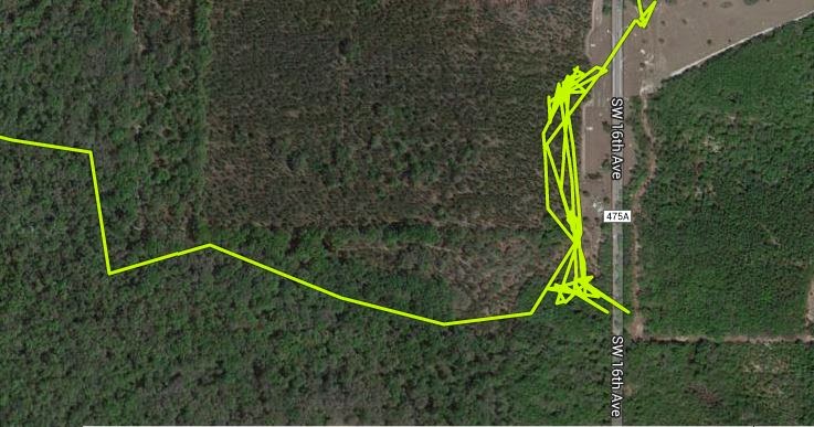
So we were still on the trails of Santos early morning Friday, making our way to the Vortex section.  CP16 was a dastardly control that had about 67 teams searching for it.  We finally got tipped off by another team.  You can see how many times we would try the same things over and over in our record GPS route below.  This was the "snowplow" control.


CP19 also fooled us since it was really tough to measure the distance of a loopy, curling trail.  But up to this point, we had not skipped one control and were determined not to miss any.


Upon reaching the Vortex sections of Santos, Robert had had enough of Santos.  A switch flipped, and he turned his navigational rampage on.  "Gotta get out of here!" he would exclaim.  For the next four controls, he pinpointed them with a crazy sense of urgency.  Oh...the "vent" control stumped us for a bit, but other than that, he got us out of Santos with utmost authority.  There was one control, at CP22, with a clue of "near vent" that in real life, was a rocky pit into a portal leading to another dimension.  It was quite surreal to see such an abyss of a hole in the ground.  It only stumped us because on one map, it was located before the red trails, and on another map, it was illustrated after the red trails.

two maps to help find controls

There was a big sigh of relief as we took a breather at a bathroom after completing the trails at Santos.  We ran into another team who one member had on shorts in the near-freezing temps.  He had bust out the emergency blanket already.  A few other guys took shelter in the bathroom in an attempt to warm up.  Conditions were super cold!  35F was reported.

This leg was not done yet.  We also stopped by a Dunkin Donuts to get people some sweets and caffeine.  This stop lifted spirits, but we noticed Bill was developing a cold and could barely talk.

As we started up again and biked into the trails that led up to Marshall TA, you could see and hear the frosty grass crackling beneath us.  We picked up CP24 along the way as the sun was rising.


Marshall Swamp was an awe-inspiring area, yet isolated in scary remote wilderness.  In the misty morning we traveled through, there were swampy cypress trees all around you, with its incredible root structure, encased in a layer of fog.  There were dirt trails, rocky trails, muddy trails, and bridges over the swamps.


Foot 4

Another meal was on order at this next transition area, and by meal, I mean cans of Chunk soup, scoops of peanut butter, ravioli, MREs, and dry-packed food.  Upon leaving, we headed out to find CP25, which was supposed to be on very wet trails.  At the entrance to the red trails, the team spent some time arguing about whether we could go pass a private property gate.  I looked down and saw hundreds of foot tracks that entered the gate.  Bill and Robert opposed, so we walked up the road some more.  Half-way up the road and after another discussion of "how do we even get to CP25 without being on the supposedly forbidden red trails", I urged the team to bushwhack straight east from where we were to hit those red trails.


Finding CP25 was pretty tough with the vague, underwater trails, and hard-to-pace-count conditions, but we eventually found it.  The team was really feeling beat by now, and crankiness and chaffage was setting in.  We found the rest of the controls on this route pretty easily.


Boat 4

At Silver TA, we launched our boats off into the really gorgeous Silver River.  They had commercialized this area, with ferries and boats carrying citizens up and down the river.  Even the giant gators nearby were used to the humans, as they did not scuttle away when we paddled up to them (they almost always do).  Tons of wildlife, including turtles, fish, and many species of birds, flocked the shores of this river.  To top it off, it was a typical sunny Florida, blue-skied day, with not one cloud in the sky.  We had a very long effortless paddle where we afforded Bill and Robert some time to sleep.


The only outstanding event on this paddle was finding CP31.  As we rounded the corner at point A, I visually gauged 200m from point A to point B.  When I could not find the opening at B, I eventually docked us at point C to find the man-made channel east of us.  After a brief scouting inland, I could not find it, so south we went.  I kept scratching my head, knowing I had tracked every corner of the river, leading us here to the correct spot.  I did not want this one to get away so I used every piece of info on the map I could, even the ever so slight kink at point D.  From D, I determined I could shoot a northeast bearing to find CP31, so we docked again, but this time at point E, where my reverse northeast bearing met the shore.  I knew this one was crazy, as there was absolutely no other solid attack points around.  I sent Nate in, who could sniff any control out if it was in the vicinity.  As he went into the marsh, I explained and tried to convince Robert and Bill my logic.  They listened to me, half awake, half thinking it was a lost cause.  As soon as I finished explaining, Nate yells my name out "Hien!  I found it!"  Ha!  Needless to say, it was voted as most outstanding control find of the race :)


The four hour paddle eventually ended at Ocklawaha TA.  The team caught some sleep there in the afternoon, and we refueled up with another meal while I sorted out the new set of maps received.

30min nap


Bike 4

I was loaded on caffeine and was ready to dominate the next few sections.  CP32-34 were pretty easy for me to pinpoint.  The sun went down again and along the way, a few things were accidentally said and assumed, some quarrels erupted, and unfortunately, it set the mood for the next dozen hours.  It was quite distracting to my night navigation, at a time where I needed all the concentration I could get.  Stuff happens when you're sleep deprived and tired.


Now we had maps that resembled the Atomic AR in Georgia--lots of elevational changes.  We were in the heart of Ocala National Forest.  The trails were very sandy, and at times, very long and uphilly.  There were no other teams around, and you could feel the cold chill you as you increased in altitude.  This night was forecast to be in the low 40s.  This place was so remote and very Twilight-Zone-ish.

CP35 was the only one to give me some trouble.  Every other CP was nailed with sharp accuracy.  On CP35, we stopped at the correct corner the first time around, but couldn't find the control.  I counted paces back from the next intersection, and we located it.  The sugar sand here was quite a challenge to ride on.  I ate sand many times trying to keep on the bike, only to hit the deck.


The Cold Sleep

At Farles TA, the team was extremely cold and sleepy by now and wanted to sleep in the back of the U-haul.  We did not have our gear bins here, so we had to make do with what we had.  I used a brief moment to continue measuring distances on the maps and to eat down several hundred more calories, in hopes of the body burning it to make heat.  Every other guy had pulled out his emergency blanket for cold protection.

Gradually, I became sleepy as well and laid down on my side, using my Camelbak as a pillow.  The floor bed of the U-haul felt like an ice block.  I toughed it up and waited for my body heat to heat the area I was on.  Ten minutes later, I awoke with the floor bed still the same bone chilling cold block it was when I first laid down on it.  So I shifted my position in a way to only allow my shoulder and arm to touch it, balancing myself on the side of my arm to minimize body contact with the floor bed.  It worked.

Ten minutes later, I awoke to some shivering that would vibrate every 10 seconds.  I shifted around and settled into a decent spot.

Another ten minutes later, Robert and Bill were gone, and Nate had awakened me with some distressed quiet yelling.  He couldn't find any comfort in the back of this U-haul, with the cold being as cold as it was.  I then noticed my my own shivering had gone violent.  Every 2 seconds, every muscle would tense in extreme fashion.  I knew that this sleep was over.  I got up, started doing jumping jacks, pushups, and anything else I could to start burning calories.  It was too cold.  We were on the verge of hypothermia.

As we got out of the back of the U-haul, the stationed volunteer saw our desperate state and directed us to the front of the U-haul, inside the cabin, where Robert and Bill were sleeping.  Oh man...the warmth in there was incredible.  There was one moment where I got back out of the truck to grab the race instructions in the back of the U-haul.  Within 5 seconds of leaving the front seat, I was back in convulsion mode.  I rapidly got what I needed and returned to the heat conditioned warmth inside the truck.  We melted and discussed what we should do next.  No one really wanted to get out of the truck, but we knew we had to move on and race.  One, two, three, and OUT!  We bolted to our gear, grabbed our packs, and ran down to the trail head.  At a time like that, you had to keep moving to warm up.  Success...about a kilometer down the trail, the team was back at operating temperatures again.

(continue to Day 3)...


Pangea - Sea to Sea AR, 72hr Expedition (Day 1)


The race came and went and my impression of the race is that it seemed to span a few weeks' worth of time, rather than a few days.  That's how the memory recalls it, at least.  There were so many things to do, so many legs of race, and so many days and nights!  We traversed exactly 350km on foot, bike, and canoe, going from one side of Florida to the other.  What an expedition!

pre-race burrito while listening to instructions

It started with us all gathering at a hotel in Ormond Beach, east side of Florida, a day before the start.  We gathered gear bins and bikes, to load into U-hauls.  It was rather windy and chilly that night and as we brought our equipment over across the street, it started to pour.  Great...what a start.  The weather forecast looked bright and sunny for the next three days, which got our smiles on.  However, the caveat was that it had some jaw-dropping 35 degree temperatures in the night.

(left) Hien Nguyen, Nathan Whitaker, Bill Dean, Robert Jordan on the west coast - team We Blame Pangea


Boat 1
The next morning, we were bused to the west coast to start a paddling section.  We received a wad of maps to look over during the ride.  Once there, the water was deemed too choppy by the race director, so we re-grouped and launched our boats off another area, more inland.

ready, set...GO!!!!

We ran to the boat launch.  There was a clog of boats as teams tried to squeeze their way into only two areas you could drop the boats into water.  Bill and Robert managed to get in first and paddled hard down river.


After finding one control point (CP) downstream, we returned back to where we came from to start a running section.


Foot 1

There were four control points in this section, after which ended in a different location at Lock TA.  We ran the entire leg and found them all with no problems, gathering CP3, 4, 5, then a bushwhack northwest towards CP6.


Bike 1

Surprisingly, we received access to gear bins here at Lock TA.  We switched to biking shoes and headed over to KP Hole TA.  Along the way, we picked up CP5.  Bill also somehow managed to unthread one of his pedals off, but we quickly fixed it.

bike repairs early on in the race


Boat 2

At KP Hole TA, we transitioned back into boats and paddled north a few kilometers to Rainbow TA.  The water on this paddling section was crystal clear, as you could see the glistening green seagrass and sandy floor below.

this water just made you wanna jump in and swim


Foot 2

On the race notes, it was said that we had to spend at least 25 minutes at this section.  On map, the entire park spanned only 400m wide, which made it very feasible.  To start, we headed up a trail too far west, but quickly corrected when we saw another team on the right trail.  I was navigating at the time and followed another team to the first control.  It appeared too easy, so I mistakenly shut the maps off and just followed the same team to the next control.  We instantly got derailed as both teams lost track and started to try to find their bearings again.  We ran into yet a 3rd team who were just as lost.

Rainbow Springs State Park - picture perfect day in the park

To fix it, we ran all the way back to the bathrooms, recalibrated and found the remaining two control points.  It took us 43 minutes instead.  Lesson learned, don't ever turn off the navigation.


Boat 3 and Bike 2

We had another paddle leg to bring us to Blue TA, where we biked to Pruitt TA.


Foot 3

At Pruitt TA, we had access to our gear bins.  We camped and had a full meal.  Here, 12yr old Hunter (from team Florida Xtreme/Hunter) had played a prank on me by putting a toy rubber snake in my bin.  Here is the footage.  I'll get you back sometime in the future ;)


The sun was going down now, getting cooler, and as we walked into the start of this trekking section, the moon was beginning to rise.  It was forecast to get down to 35F this night, so I wore every piece of cold clothing I had.

walking away from the sunset and into the chilling night

What was crucial on this leg was that you had to look at the kiosk along the trail to understand that there were more trails to travel on, rather than the few illustrated on the maps we had.  Luckily Robert had a digital camera and was able to snap me some photos that really helped.  This was backed by some great pace counting by Nate and Bill.

We found CP11 and 12 while helping out team The Derailleurs.  Heading to CP13, we walked down a trail that was mapped on the kiosk, but not on our maps.  However, the trail became faint and eventually disappeared, so we used some brute force foraging to eventually find it.  We actually found it while bailing out to the road east of us to re-calibrate :)


Bike 3

Ross TA was a few hundred meters away and the start of a super long bike ride in Santos.  Robert took over the navigational role here, as he knew these trails the best out of all of us.  Looking at the map and being here a couple times before, I knew this section would provide the toughest navigation of them all, esp. in the night.  The controls were not on the trails, as they usually are for technical biking.  They were about 100m off the trails, which made it very challenging to find if you did not locate your attack points precisely.

Santos biking trails map

Sure enough, CP14 started off the time consuming hunting sessions.  We attacked many times and used many techniques to find the correct attack point--go 1.5km to a downhill that kinked southeast, find the re-entrant, shoot in; if not, locate where the two blue trails are closest together down the trail, and measure backwards.  Eventually, we found it.

Up to this point, we had fallen behind a familiar pack of teams, but the first few controls here were so tough we caught back up to them as we ran into the same pack again.  Luckily, we were always the first to find the controls for the pack.  Anytime we shouted to call our control puncher guy, it was like waking up all the other zombies and having them head towards us :)

(continue to Day 2)...