
Canyoneros finally took a podium spot after two years of mucking through waist-deep mud and cow dung fields as fast as we could! Only a few can appreciate this madness, and to me, my first medallion is a reminder of how exhilarating and wild the sport can get sometimes.
Team Canyoneros - Stuart White (left), Hien Nguyen

This race marks the debut of Stuart White, a triathlete who approached us at the RDV Sportsplex, expressing interest in the apparently crazy sport we do. So we brought him out to a Florida Orienteering event, where he passed the test of not hesitating to jump into creeks to cross them, a sign of a Canyonero, marked with tunnel vision of the bigger goal in mind--orange and white CP boxes. He also pushed our running pace so fast that we cleared their white course for warm-ups in an official time of 4 minutes, the next best being 44 minutes :)
Foot 1 -> CP1, 2, 3, 5, 4 order


race instructions (yes, that is Canyonero blood)


CP1 was a matter of following the trail curves and bends, both on trail and on map, until the southwest bend was apparent, and then shooting a bearing directly to the CP. We then went clockwise on the rest (CP2, 3, 5, 4). The main reason we chose this orientation was because we felt it lent itself to more accurate attack points, namely CP5, which appeared to be in the middle of the woods. There was a distinct trail corner to attack from, and luckily, there was a non-mapped trail leading to it, but there was no path leading down into it from the north, unless you accurately counted paces before you headed directly south into the control point--this was the riskier option to me.

CP4 was a matter of going to the furthest, most eastern part of the trail curve and then shooting a bearing in until you saw a wetland. The wetland was big enough to provide a margin of compass and human error.


Canoe - CP11, 12, 14, 13, 18, 20, 19, 16, 17, 15 order
carrying paddles on the way to the Boat TA

Once done with the first trek portion, we headed back to Foot TA to pick up paddles and bike to the Boat TA. You can do all the Google Earth research you want beforehand, but it hardly prepares you for the Swiss cheese that is St. Johns River, filled with sporadic lakes and channels. Last year when I raced the Boar, we purposely chose to only gather the CPs on the main route and nothing in the hairy interior of St. Johns.

race map

With one year's experience since the last Boar AR, I have to admit that I've gained the confidence to navigate rivers you can easily get lost in--minus the nighttime, that is. Stuart and I hit CP11, 12, 14, 13, precisely, before stumbling on CP18. Our first attempt at docking the boat was correct (image below), but unfortunately, we listened to a following team who thought we had not gone far enough. We moved forward and identified another potential docking point, ran on foot until I saw the boat ramps. That's when I knew we overshot it, and that our first docking point was the correct one.
first attempt--me shooting a direct bearing to the line of trees that housed CP18

So we called off CP18 and from there on out, it was a battle against the almighty winds, shallow seagrass, and the airboats manned by guys who looked like Afghan terrorist soldiers. In many areas we had to get out of the boat and pull it forward because the waves turned the canoe backwards if you stayed in to fight it.
waves surging against us

knee-deep in the smelliest water ever

Going south and rounding the river towards CP15, it was too shallow so we walked in shoe-stealing mud. I got the idea that it doesn't take two to push it, so I ran on the shore and alongside the "palm grouping" to find the CP while Stuart pushed the canoe to meet me down the river. It worked and saved us the time we would have spent to push the canoe and then find it. Why not do both at once?
Bike 1 -> CP7, 6, 8, 9, 10 order
race map
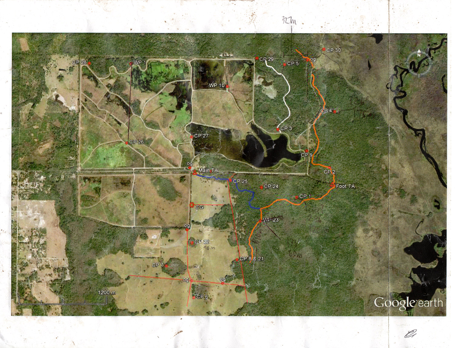
For CP10, you had to go to WP10 (a reference point), shoot a bearing towards the southern most radio control tower you saw to the west, and with that line on the map, make it intersect an imaginary line drawn from WP1 to CP26.

We adventure racers are clever thinkers. Instead of taking a longer route to WP10, why not just draw the imaginary line and go up every trail that intersects it (green dots above)? The swamps and fields in between the trails were infested with gators, so chances were high that the CPs were only along the trail. We were not alone in this, as there were other teams who we saw doing the same, or reported doing it. However, it was not so convenient, as it had us going to the very last trail that intersected the imaginary line :) We can imagine it still saved lots of time though.

On our way out of CP7, we rounded a forest cluster and saw a bull or cow bolting towards us! I was seriously bracing for impact, so I got off my bike and planned to throw it at the bull and jump out of the way if he charged at me. Luckily, our Canyonero aura scared the bull off, causing him to trip and fall over to avert danger (us).
video of bull charging at us. He knew better though ;)
Bike 2 -> CP27, 26, 28, 29, 30 order
We were doing fairly well on time and Stuart had picked up a second wind on the biking portion, so we continued to bike. All of them were picked up with not much navigational focus, but CP28 did have three trail openings nearby that we went into before finding it.
we must have ridden this trail a dozen times during this race

At CP30, we estimated 15-20 minutes to head back and out on foot. With about an hour left, this was the period of the race where we had to increase our time awareness. Always ask each other how much time is left after every CP or transition and try to figure out a plan of dropping CPs that are far or tough.
Foot 2 -> CP25, 24, 23 order (skipped the other two)
I am usually the one who drinks the most water, but amazingly, my three liter Camelbak lasted all 6hrs! On top of that, I finished the race only drinking 3/4 of it, which means my body has been adapting to all the endurance training I'm putting it through. The cooler weather helps too :)
FL jungles

With 45 minutes left, we reversed our morning plan and ran the route backwards to gather the closest CPs first. I knew CP24 would be the hardest. Sure enough, we shot the bearing at the incorrect first sharp turn of the trail to the south (pic below). We saw a wetland, but the control was nowhere to be found. We lost 12 minutes on that attempt and called it off. The race map did not show such a sharp turn where we attacked in, so we figured we had run far enough to the correct second one. We poked back out on the trail, continued to run towards the next control point, but found Ron Eaglin shooting a bearing into the correct trail corner, so we followed. He was someone we could trust. His teammate admitted that they erroneously did the same thing we did, as did a couple more teams I came to learn afterwards.

How do you prevent that? From CP25 to the correct corner is roughly half a kilometer. Ideally, one guy would be in charge of using a stopwatch to measure time traveled. At a pretty good off trail pace (6mph), that's a little more than 3 minutes to travel half a kilometer. So if the clock shows 2 minutes and 15 seconds after resetting the stopwatch at CP25, then you know you have not gone far enough. Putting it to practice takes a while to make habit out of, but does wonders for times like this. Plus, through training, you'll develop a sense of what a 6mph pace is. The only catch is that if you stop or change average speeds, the measurement becomes less and less accurate, which is what will happen 5hrs into racing :)
After CP23, there was only 20 minutes left, so we headed back and won third place!
falls like this happen pretty frequently; get up and pretend it didn't happen
our recorded GPS route (32.72km of it was biking)
No comments:
Post a Comment