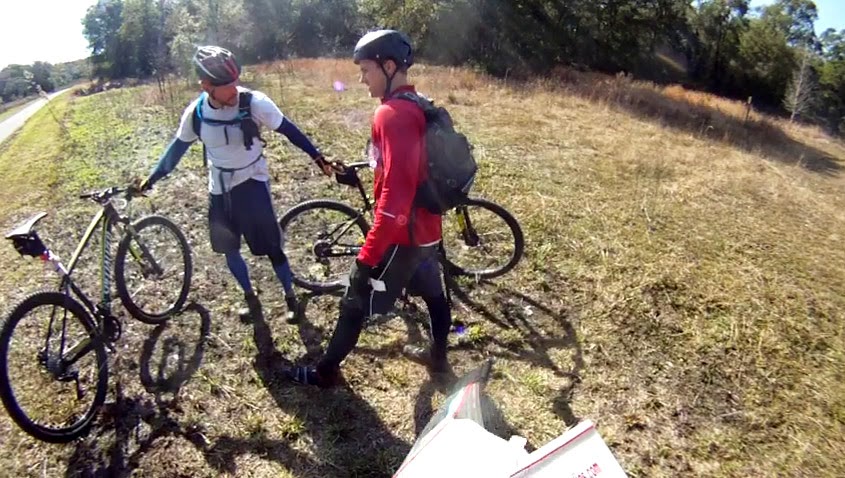
Monday, February 9, 2015

FLX - FL Rogaine, Elite 8hr


Rogaine is a type of race where there are lots of control points out there and you develop your own route.  But we have never officially done one.  Today was an opportunity to combine our specialty of orienteering and grinding endurance to train for the Sea to Sea AR next month.  Who woulda thought we would run a full marathon out here today--all offroad?


By the way, we signed up under the team name of "Canyoneros - EA Sports".  Over the years of adventure racing, we have become fortunate enough to maintain the health and skills needed to do satisfactorily well in this sport.  Our work place, Electronic Arts (also known as EA, the maker of video games such as Madden NFL, Fifa, Battlefield, the Sims, and more) has been very gracious enough to sponsor us!  We will be also running the Sea to Sea AR to raise funds for the Wounded Warrior Project, while carrying a GPS spot tracker to bring the action to those at home (link to be posted when the time comes).

Onto the race...the race was broken up into two halves.  You would find 15 controls in the first half and 14 controls in the second half.  Nate and I each planned a unique route to compare afterwards.  He's been in full navigation training mode to better help me out when I fall asleep at the Sea to Sea AR next month.  Mine went counter-clockwise and his went clockwise.  They were basically mirror images of each other so we just stuck with mine.

route - 1st half

I would say for the most part, everything went fairly smoothly, so I wanna use this blog as a post-analysis on some of the more technical points of the first half of the race.

At control point 32, I admit, we did latch onto some faster teams out there (one of our rules to not do) and got lost.  There were fainter trails out there (point A) that I thought were mapped and did not pace count to confirm it.  Luckily, we backtracked our thinking, realized the lower elevation (point B below) to re-calibrate our bearings, and found the control with the help of other teams nearby.


At CP53, we found the small depression (point A) and then shot another bearing to the control.  However, we blew right by it within 15m, bailed out and found it at point C.  As we exited, it was time to flip the map over.  I couldn't really line up where it connected, so I had us bushwhacking straight down at point D, instead of the more efficient point B.


With forests so open and us having great luck at finding CPs so far, we decided to do a little test.  Jim Gorton was right on our tail after punching CP62 and while heading towards CP74, he caught up to us but stayed on trail.  We decided to bushwhack about 1km to CP74.  That's a massive length for mere mortals to stay straight on, so we went shot from depression to depression.  Lately, Nate has been using old maps at Wekiva to find every single depression there is in that park, and rightfully deemed himself the master of the depressions.  This further gave us more confidence to reign our line back in if things went crooked.  It proved a success and we even beat Jim to the control using the shorter path.


We had remembered from last year's Sea to Sea AR that the trails here were often very faint or non-existent.  Here you can see we ran right pass this trail (A) and didn't figure it out until we started going north.  Constantly looking at the compass allowed us to fail quick and cheap.


After grabbing CP73, we could have gone for the furthest CP81, but totally forgot to write the complete route order on the 2nd map.  Nate did some rough calculating and determined CP81 would cost about another 15-20 minutes, so we chucked it on the belief that the course was not clearable and that CP81 was the worst bang for the buck.

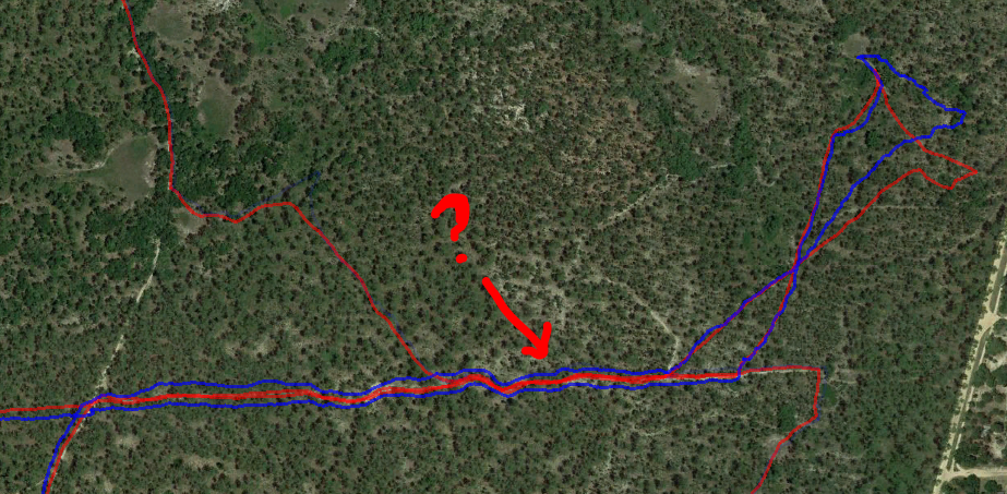
At CP71, we counted 6-700m to get to the intersection at point A to shoot a bearing to the control.  We badly missed the control.  Then we started scavenging to the north to find a mapped depression/marsh at point B.  It was there we found a better attack point to hone in on the control.  What happened?  Upon reviewing the map overlaid with Google Earth, trail A did not exist, but trail C was the larger more prominent one we got confused as trail A.


motocrossers enjoying the beautiful day

At the end of the first half, we tried to find this trail to lead us directly to the Main TA (point A) but it didn't exist in real life so we were forced to take the next trail, which also didn't exist, so the next.  Again after reviewing the 'tapes' we see that the entry to the trail is blocked by a tree and the other side is just overgrown--not identifiable at all.  That's alright, you gotta be on your toes for backup plans when it comes to adventure racing.


point A, zoomed in on Google Earth


route - 2nd half

The second half seemed to be tougher to figure up a route, due to the two controls in the middle of the course that threw off the circular path (in our case, clockwise).  At the Main TA, I duct taped my feet due to ease some hot spots (something I will have to keep in mind for the Sea to Sea AR).  We planned the route on the fly during bushwhack walks to minimize down time.

Nate dons the GoPro now!

I originallly planned a route that had us going from CP 33 to 34 to 54.  After punching CP33, the plan was forgotten and we skipped 34.  Realizing it too late, we had to re-configure our entire route on the back end.  The original plan had us going to gather CP 44 and 45 easier, but now had us going far out of our way to swing the route out west.  We decided to write down the order finally.


this is what a "pit" looks like

There was an area in the park that seemed like it was hit by a tornado


We spent a good amount of time (~15min) trying to find CP83.  Turns out if we stuck to the original trajectory we had, coming from the cemetary, we would have found it on first try.


Heading to CP64, we made an astounding discovery.  CP64 was in between the front side of our map and the back side.  I needed to shoot a bearing, but couldn't, so I took Nate's map and connected it to mine.  Things didn't line up correctly from left to right.  The scale on the front and back were not the same!  It affected me because I was using a new AR UTM ruler that had the 1:15,000 scale on it.  No wonder our measurements were out of whack on the southern end of the park.  Having no good way to shoot a bearing, I started counting paces up, right, up, right, pretending I had hit trail A.  I never found the trail, although it appears we were so close, but stuck to the theoretical plan.  Nate is like an NFL kicker.  Get a kicker closer than 50yrds of the goal post, and your chances of nailing a field goal are higher.  However, with Nate, I knew if I could get him within a whopping 200m, he would have a chance of sniffing it outright.  He spotted this one within 125m away!


I'm not kidding about Nate.  Here's another example--150m away is where he found it.


We had a good amount of time left after getting CP34, but rough hand measurements revealed too much distance to gather the last two controls to the west, CP44 and 45.  It might have been doable at the beginning of the day, and if the trails were paved, but not at the end of the day in the off-road trails.  We ditched it to not risk time penalties.  In fact, it appears penalties with rogaine rules are extraordinarily harsh--one point penalty every minute you're late!  Check out the sport teams who came in late, some of them have terribly negative scores!

Enroute to the finish, we wanted to take the red route (below), but as the trail we were on started going multiple directions except northwest, we said "screw it, let's just take a bearing from the last CP and shoot straight to the Main TA."  If in doubt, use brute force :)


We finished 1st in the team division, 2nd in overall.

Saturday, January 17, 2015

FLX - Resolution AR, Elite 8hr


The original members of the Canyoneros decided to go back out to the same venue that hosted our very first adventure race ever, with race organizer WeCeFar at the 8hr Croom Crusher (of 2010?).  To this day, we still spread legendary stories of amoeba and mosquito attacks, old fairies escorting us through the race, the throwing up of gallons, and Paul Bunyan pumping up a crowd of patriotic folks at their locally famous Margarita Grill (now burned down).  We would not adventure race again for an entire year.

Fast forward to 2015, we revisited the Croom again and saw many familiar areas. It was great to see how far we had progressed.


Here was highlight of the first running portion, a control in a deep quarry.


Orienteering was our 2nd leg and what I like to call my bread and butter.  CP27 gave me some trouble since the paths were very subtle at times near there, but we finished in 2hrs and a couple minutes.  While trucking through the forest, Russell ran into a 25ft tree and knocked it down.  Greg had eagle eye with the CP spotting.


I enjoyed the little games we had in this race.  This particular control did not have a punch, but a sign that told you to shoot another bearing to find the real punch.


The canoeing was perhaps the most exciting part of our race.  It took a bit for us to get the 3-man technique going.  We got it going really smoothly on the return route.  It was much better than the very first time at the Croom Crusher, where I swear we had the canoe backwards, as we zigzagged to no end.  Along one of the bends, we got our canoe stuck and pivoting on top of an underwater cypress stump, aka "death stump".  Anytime Russell is in your canoe, rest assured, you will capsize, and along with it a backpack will float back down the river.

the capsize

The water got stronger and stronger as we got near CP32.  We had a couple attempts at trying to paddle up this channel, but it proved too strong for the three of us in a clumsy canoe.

canoeing upstream

I decided to jump off onto the bank and find the control, which was about 75m away.  While jogging over, I had a suspicion I chose the wrong bank to go on.  Sure enough, I did and had to jump into the cold river to punch the control.

swimming for CP32

This control was in one of the coolest environments I saw.


CP14 gave me fits as we kept trying to find a tree in the middle of a many clusters of palmettos near there.  Turns it out it was in an open area of the forest with no palmettos nearby.  For having not ridden a bike in a year, Russell hit the wall during our final bike leg, so Greg roped him up and towed him back.  We finished 8th out of 22 this time around, coming in 19 minutes late.  It was quite fitting, as Greg Watson put it.  In comparison, we had finished 40 minutes late at the Croom Crusher and got DQ'd and last place.  Manny Otero put on a great event that had us revisiting the past.


Canyoneros - Greg Watson (left), Hien Nguyen (me), Russell the Muscle


Saturday, November 29, 2014

Pangea - Turkey Burn, Elite 12hr


The Turkey Burn of 2014 marked the final Pangea Adventure Racing event.  It was held at Wekiva State Park.  Temperatures dipped in the low 40s as we drove out there around 1am.  Cold always means higher endurance for us.

Dave Brault designed a unique prologue for us to do.  We had to disassemble the front wheel of one of our bikes, run in opposite directions in a predefined trail loop, meet up, reassemble, and then head off into the first section of the race.  Also unique to this race was that we were receiving maps at the beginning of each section, which took pre-race planning out of the agenda.


Foot 1
We picked up one CP while biking over to Wekiva TA.  Once at the transition area, we switched to foot and started finding five controls with everyone in the dark.  When you have a massive pack to start, there's really no issue in finding them.

You can reference maps on team Nature Calls' blog.

Bike 2
Nate and I made a quick transition to bikes and starting making our way to the front of the pack, near team Endeavor Racing and Florida Xtreme Hunter.  There were five more controls to visit on bike, most near intersections to keep things fast and flowing.

Canoe
We were the second team heading into the river, embarking on a very long paddle section.  Rock Springs Run can be hard to navigate with its more subtle features, so I'm assuming that's why we did not have any controls on that river until about 5km later, at CP13, which was 200m from the Wekiva River.  Out of sheer luck, as I called for us to rethink where we were to snap us out of monotonous zone, Nate spotted the control immediately.

We slowly inched our way closer to team Endeavor, but at the far end of the river, where CP20-22 were, they found them much faster than we did and gained another 5 minutes or so from us.  Nate and I have paddled these two rivers for years.  It's literally our backyard.  We ended up with a time of 3hrs 37min, tied with team Endeavor Racing for the fastest time.  It was the best paddling I can remember us ever doing, for this long.

dawn on the river


saved!


picturesque environments

Foot 2
We were in second place all the way until CP27, where my GPS reported we spent close to 30 minutes trying to find this control.  We initially attacked in at a distinctive north trail bend (on the east) and then re-attacked at the upper northwest intersection.  This is where teams caught back up to us and we worked together, but after a while, Nate and I decided we had spent enough time here.  With 55 controls set out, we had to average one control per 13 minutes in order to clear.  We heard later that other teams finally found it, either while bailing out or by sheer determination.

CP36 was the last of the controls on this leg.  It had a tough bushwhack going in, and a memorable bushwhack going out.  The exit had us going through some tough vegetation.  Nate and I frequently bike Wekiva along their 8 mile loop and always wondered what it would be like to find controls in the vast fields of palmettos that take over the land after a controlled burn.  Now we know...there is no flat ground haha.  It is filled with palmetto root, razor bladed stems, and tough rigid twig-plants (that's the best I can describe it).  This was enough to put all the bruises, cuts, and blood on us for the entire race, despite us trying to follow the edge of the swamp and palmetto vegetation.

the elusive CP27 and our hunting area

one of many kinds of environments at Wekiva State Park - couldn't have asked for nicer skies

teams working together

happens to me at least once a race, while concentrating too hard on the map


Bike 3
We headed back to Big Buck TA to head to Rock Springs Run State Park  It started with crossing Rock Springs Run river with our bikes and punching a control we had previously punched on canoe.

I had biked here once to train and it was sugar sand heaven, or hell, depending on how you enjoy it.  We found a couple controls before we converged again with Florida Xtreme Hunter and Honey Stinger, where they were debating heading back due to time constraints.

Here, we were presented with the option that would determine the race for us.  We knew if we headed back with them, we would lose by 1 point to them, due to us missing CP27 before.  We started gambling with decisions now, and I called for us to find two more biking controls, while finding shorter routes back to Wekiva.  At first the shorter routes were only slowing us down by a little bit, but as the route continued, conditions got muddier and messier.  Then it got overgrown and we were slowed down to a crawl.  This is where we knew we had botched the race.

There were two more quick controls to pick up on the way back to the final transition area.  Luckily we ran into another team at the final biking CP47, who reminded us to go to Wekiva TA, not the Start/Finish TA.  I had already been biking to the Start TA before Nate called me back.

crossing rivers with bikes


Foot 3
We rushed to Wekiva TA with time ticking and smoothly transitioned off to find the lower four controls, which were the exact ones we found in the morning.  They were much easier in the day.

During the race, our stop watches had occasionally paused here and there, bouncing off the wrist, giving us an erroneous readout of how much overall time we had left.  Once we figured out the real time left, we realized we were wrong by about 30 minutes and had to scramble even more.  At that point, we knew we'd run late, so I called us to find two final controls, knowing we'd go overtime--I just didn't wanna go over the 10min 2-point penalty period.  The last control only chewed up about 3-4 minutes, so it was a gamble whether or not it was worth it (turns out it didn't really make a difference in the standings).

The bike back to the Start/Finish TA was fast to say the least.  We took a known path along the 8 mile loop we usually go (west of Wekiva TA to the horse coral) and then road back on paved roads for the 2nd fastest time (18:50 min) behind Team America.  Most teams took the south road, but from morning memory, it was deep sugar sand and so we gambled again on the other end.


plenty of razor-stemmed and pointy palmettos

John Sheriff, showing the camera who's boss

All in all, we had a great challenge of a course.  When you don't have all the maps at first, you never know how your decisions will affect the end.  We gambled here and there, some paid off, some didn't, but that's how it goes with adventure racing.  We were suprised we still ended up 5th overall.  Big congrats to team Florida Xtreme Hunter, who made great decisions and took the overall top spot (also sports the youngest racer in the elite race).

We'll sorely miss Pangea Adventure Racing, who home-grew us into the sport.  Neither Nate or I had any running, orienteering, or endurance backgrounds at first, but it was so fun and challenging anyways.  Pangea Adventure Racing has changed our lives in ways we never knew.

In light of this, adventure racing will still continue with Florida Xtreme Adventures!  Keep going outdoors!

Ron Eaglin presenting Greg Owens "Adventure Racer Emeritus"


Sunday, October 19, 2014

Pangea - Lighterknot AR, Elite 8hr


Three years ago, we participated in our very first Pangea race, the Lighterknot AR of 2011.  We set out with three teams and finished bottom three.  However, there was something about adventure racing that kept us coming back.  No race was ever the same.  Nate and I can name any race we've done in the past and instantly recall the great stories of the experiences.  And that's what makes adventure racing so great for us.  Ironically, the best stories we have aren't the ones where we placed higher on the leader boards, but the ones where we were completely lost in the woods, fearing for our lives, wondering what comes next, while the sun was setting and our water running out.  That's what keeps the blood flowing, and that's what creates the lifetime stories.

Fast forward three years later, and team Canyoneros has finally achieved our very own "first place overall" (technically second time, but the first time was with the unstoppable Dave Ashley at the helm).

This year's Lighterknot AR was designed by seasoned racers, Craig, John, and Jamie Sheriff, team "Sheriff's Posse".  It was held across Faver-Dykes State Park and Pellicer Creek Conservation Area of St. Augustine.

team Canyoneros - Hien Nguyen (me, left) and Nathan Whitaker


Prologue on Foot

Dawn had barely cracked its amber hue on the horizon before we were off on a 32 minute foot prologue to find three controls.  The cooler morning chill was a great welcome that supercharged our running as we collected CP 1, 3, and then 2.  We had a bit of issues at control 3, spending almost 10 minutes finding it.  I always have the toughest time calibrating my navigation on prologues, where we tend to put more efforts on speed than accuracy.


Canoe

After the run, we biked a few minutes over to the canoe launch, took team photos, and paddled off east towards the St. Johns River to collect CP4 before the open water picked up more chop.


The river was a perfect setup of easy-to-identify bends that made navigation ideal.  As it turned out, we were primarily at the end of a pack of canoes following the leader.  The advantage was that we didn't have to search for the CPs, which gave us the fastest time in this leg.  Once done finding them all, we ended up in another location further up Pellicer Creek to start an orienteering foot section, with another map to be provided there.


Foot 1

There were three controls to pick up, and we took Craig's suggestion of getting CP11 first.  It took Nate and I a bit to warm up our legs after paddling an hour and a half.  Our legs got stiff sitting there in the canoe, motionless, and the weather cooler than usual.  Try running without bending your knees.  That's what it was like.  It was great that the canoe section was split up with another discipline in the middle.


My plan for finding CP11 was to run to the landbridge, measure a distance and bearing for backup, and travel alongside the lake.  This map scale was in miles, so Nate helped me out by converting all of my on-the-fly and eyeballed measurements to metric since we are much more in tune with pace counting in meters.  We met team Mojitos on Monday there, where they had found it.

Getting to CP10, we just wanted to get a rough bearing towards the large man-made, squared pond to the south.  The bearing didn't have to be precise since you had a huge room for error, and if you overshot, the control was close to the road anyways.  Once we got there, we ran up and down its west border and found it.  CP9 didn't give us any trouble, as we used our steady jogging to complete it efficiently with the fastest time.

"ring cut pine"

As we headed back to Pellicer TA, we were happy to hear we had taken the lead.  This has happened in the past for brief moments, but they were just that...brief.  Nate had the eye on the prize, the wooden trophy, and did all he could to back me up on navigation from there on out.  The excitement produced some high heart rate jitters on our paddle back.


Bike 1


On map, the biking portion looked straightforward with a counter-clockwise loop.  Some controls were deceivingly close for a biking segment, and Craig confirmed our suspicion in the morning by going around and telling us all that there were a number of flooded areas.  We took all of his suggestions, starting with taking the detour at CP2 to head north.


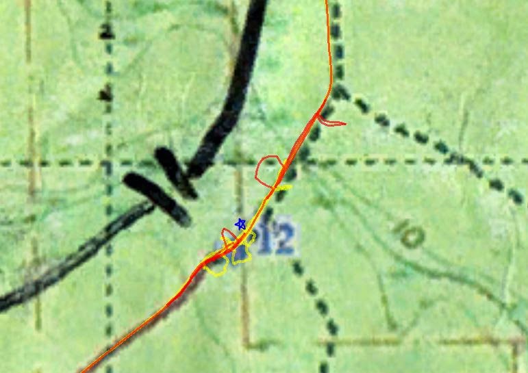
CP12 was where the three teams converged again (Mojitos on Monday and Broccoli Covered Powder Babies).  That's 8 sets of highly experienced eyes hunting for 20 minutes.  Nate and his hound dog, control-sniffing ability finally found it (blue star below).


Once we punched it, others converged in and continued north to CP13 with us.  Nate was beginning to experience first symptoms of heat exhaustion.  With only 4½ hrs in, we needed to slow the pace down to prevent it from going full-blown.  The other teams slowly passed us and visions of first place once again slipped away from us like it always did in the past.  If they were faster as a team, there was not much we could do with so much race left.  But somehow they blew right by CP13.  My pedometer reading stopped me in our tracks, and I had to double check my measurements to be sure I wasn't wrong.  A couple sniffs while I was doubting/fumbling with the map, and Nate's nose had honed in on it again, at the exact location I stopped.  By then, the other teams were far gone down the trail.


Nate's condition was getting worst.  I had him set whatever medium pace he could manage.  I can easily tell when he gets into heat exhaustion when his cheekbones are red and he's sweating profusely.  He'll be the last to admit it, that stubborn Englishman :D.   "Forward!  I want that wooden trophy!" he would proclaim as I regularly encouraged stops.  We couldn't find time do any long endurance biking before this race--nothing longer than 45min.  So for the flooded trails, we simply walked most of it.  On the flipside, my thinking is much clearer when my heart rate is down and oxygen can get to my brain better, so we were surgical on finding the rest of the controls on this leg, netting us the 2nd fastest time behind team Area Goats.


We made multiple stops along the flooded trails for Nate to defibrillate himself with cooler muddy water on the body :D


Foot 2

It was a treat to finish the last bit of the biking segment on paved roads.  As we pulled up to the main TA and got off our bikes abruptly, both of us immediately locked up in severe leg cramps.  I was meters away from the staff, trying to hop over, but just could not move my Frankenstein'd legs that had gremlins clawing to get out.  Nate's finally subsided and he was able to take the punch from me to turn it in while I sat down and stretched.  Nate ran back to our camp, poured cold water on his steamy head, and grabbed me to head back out, still with biking shoes.  Those were the worst leg cramps I have ever had to date.


We hobbled out of the main TA at a speed slow enough to manage our cramps.  With the exception of trying to figure out where the trail head near the campground was, we found all four controls here with no issues.  CP23 appeared the hardest, but our pace counting amazingly got us there almost exactly.  Eventually, we settled on a pattern of 2-5min trot, 30 second walk to finish the race, since the cramps and stitches kept flaring up.  Believe it or not, we had a lot of heat training leading up to this race and it still got the better of us, despite a cooler than average day.


Other Notes

The tree stump trophy in the first photo above is wood called "lighter knot", hence the race's name.  It is also called "fatwood", which apparently lights up in flames pretty easily and is used in the production of dynamite.


Nate's Stats