Sunday, October 19, 2014

Pangea - Lighterknot AR, Elite 8hr


Three years ago, we participated in our very first Pangea race, the Lighterknot AR of 2011.  We set out with three teams and finished bottom three.  However, there was something about adventure racing that kept us coming back.  No race was ever the same.  Nate and I can name any race we've done in the past and instantly recall the great stories of the experiences.  And that's what makes adventure racing so great for us.  Ironically, the best stories we have aren't the ones where we placed higher on the leader boards, but the ones where we were completely lost in the woods, fearing for our lives, wondering what comes next, while the sun was setting and our water running out.  That's what keeps the blood flowing, and that's what creates the lifetime stories.

Fast forward three years later, and team Canyoneros has finally achieved our very own "first place overall" (technically second time, but the first time was with the unstoppable Dave Ashley at the helm).

This year's Lighterknot AR was designed by seasoned racers, Craig, John, and Jamie Sheriff, team "Sheriff's Posse".  It was held across Faver-Dykes State Park and Pellicer Creek Conservation Area of St. Augustine.

team Canyoneros - Hien Nguyen (me, left) and Nathan Whitaker


Prologue on Foot

Dawn had barely cracked its amber hue on the horizon before we were off on a 32 minute foot prologue to find three controls.  The cooler morning chill was a great welcome that supercharged our running as we collected CP 1, 3, and then 2.  We had a bit of issues at control 3, spending almost 10 minutes finding it.  I always have the toughest time calibrating my navigation on prologues, where we tend to put more efforts on speed than accuracy.


Canoe

After the run, we biked a few minutes over to the canoe launch, took team photos, and paddled off east towards the St. Johns River to collect CP4 before the open water picked up more chop.


The river was a perfect setup of easy-to-identify bends that made navigation ideal.  As it turned out, we were primarily at the end of a pack of canoes following the leader.  The advantage was that we didn't have to search for the CPs, which gave us the fastest time in this leg.  Once done finding them all, we ended up in another location further up Pellicer Creek to start an orienteering foot section, with another map to be provided there.


Foot 1

There were three controls to pick up, and we took Craig's suggestion of getting CP11 first.  It took Nate and I a bit to warm up our legs after paddling an hour and a half.  Our legs got stiff sitting there in the canoe, motionless, and the weather cooler than usual.  Try running without bending your knees.  That's what it was like.  It was great that the canoe section was split up with another discipline in the middle.


My plan for finding CP11 was to run to the landbridge, measure a distance and bearing for backup, and travel alongside the lake.  This map scale was in miles, so Nate helped me out by converting all of my on-the-fly and eyeballed measurements to metric since we are much more in tune with pace counting in meters.  We met team Mojitos on Monday there, where they had found it.

Getting to CP10, we just wanted to get a rough bearing towards the large man-made, squared pond to the south.  The bearing didn't have to be precise since you had a huge room for error, and if you overshot, the control was close to the road anyways.  Once we got there, we ran up and down its west border and found it.  CP9 didn't give us any trouble, as we used our steady jogging to complete it efficiently with the fastest time.

"ring cut pine"

As we headed back to Pellicer TA, we were happy to hear we had taken the lead.  This has happened in the past for brief moments, but they were just that...brief.  Nate had the eye on the prize, the wooden trophy, and did all he could to back me up on navigation from there on out.  The excitement produced some high heart rate jitters on our paddle back.


Bike 1


On map, the biking portion looked straightforward with a counter-clockwise loop.  Some controls were deceivingly close for a biking segment, and Craig confirmed our suspicion in the morning by going around and telling us all that there were a number of flooded areas.  We took all of his suggestions, starting with taking the detour at CP2 to head north.


CP12 was where the three teams converged again (Mojitos on Monday and Broccoli Covered Powder Babies).  That's 8 sets of highly experienced eyes hunting for 20 minutes.  Nate and his hound dog, control-sniffing ability finally found it (blue star below).
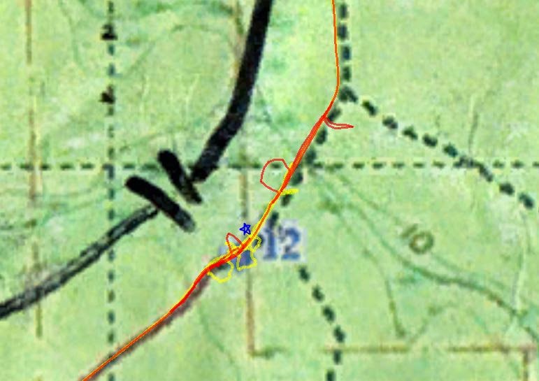

Once we punched it, others converged in and continued north to CP13 with us.  Nate was beginning to experience first symptoms of heat exhaustion.  With only 4½ hrs in, we needed to slow the pace down to prevent it from going full-blown.  The other teams slowly passed us and visions of first place once again slipped away from us like it always did in the past.  If they were faster as a team, there was not much we could do with so much race left.  But somehow they blew right by CP13.  My pedometer reading stopped me in our tracks, and I had to double check my measurements to be sure I wasn't wrong.  A couple sniffs while I was doubting/fumbling with the map, and Nate's nose had honed in on it again, at the exact location I stopped.  By then, the other teams were far gone down the trail.


Nate's condition was getting worst.  I had him set whatever medium pace he could manage.  I can easily tell when he gets into heat exhaustion when his cheekbones are red and he's sweating profusely.  He'll be the last to admit it, that stubborn Englishman :D.   "Forward!  I want that wooden trophy!" he would proclaim as I regularly encouraged stops.  We couldn't find time do any long endurance biking before this race--nothing longer than 45min.  So for the flooded trails, we simply walked most of it.  On the flipside, my thinking is much clearer when my heart rate is down and oxygen can get to my brain better, so we were surgical on finding the rest of the controls on this leg, netting us the 2nd fastest time behind team Area Goats.


We made multiple stops along the flooded trails for Nate to defibrillate himself with cooler muddy water on the body :D


Foot 2

It was a treat to finish the last bit of the biking segment on paved roads.  As we pulled up to the main TA and got off our bikes abruptly, both of us immediately locked up in severe leg cramps.  I was meters away from the staff, trying to hop over, but just could not move my Frankenstein'd legs that had gremlins clawing to get out.  Nate's finally subsided and he was able to take the punch from me to turn it in while I sat down and stretched.  Nate ran back to our camp, poured cold water on his steamy head, and grabbed me to head back out, still with biking shoes.  Those were the worst leg cramps I have ever had to date.


We hobbled out of the main TA at a speed slow enough to manage our cramps.  With the exception of trying to figure out where the trail head near the campground was, we found all four controls here with no issues.  CP23 appeared the hardest, but our pace counting amazingly got us there almost exactly.  Eventually, we settled on a pattern of 2-5min trot, 30 second walk to finish the race, since the cramps and stitches kept flaring up.  Believe it or not, we had a lot of heat training leading up to this race and it still got the better of us, despite a cooler than average day.


Other Notes

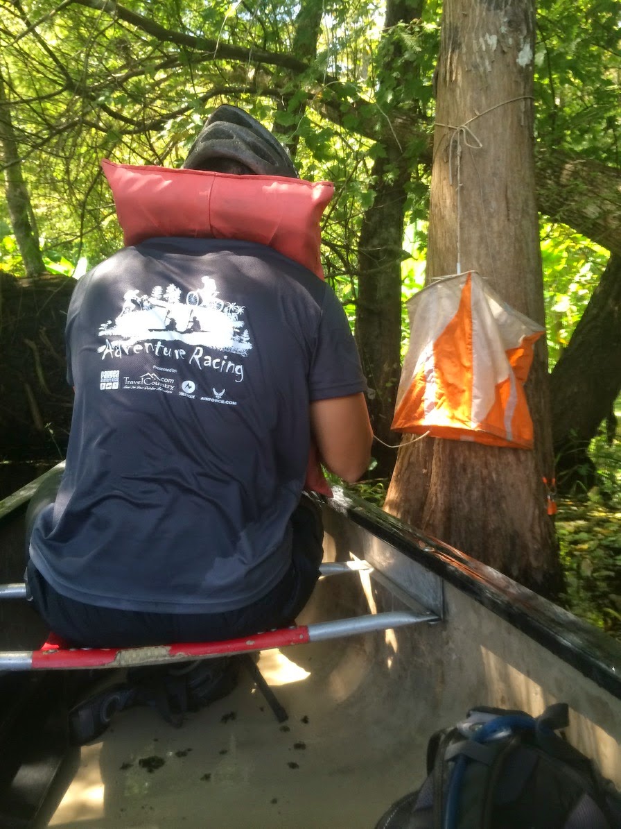
The tree stump trophy in the first photo above is wood called "lighter knot", hence the race's name.  It is also called "fatwood", which apparently lights up in flames pretty easily and is used in the production of dynamite.


Nate's Stats


Sunday, September 14, 2014

Pangea - Superhero AR, Sport 3hr (Newcastle Boyz!)


Newcastle Boyz – Aaron (left), Nate, Omer, Nathan


Pre-Race
This was my (Nate) and my son Aaron's second time at attempting a sport race with myself at the navigation helm. For this race we were joined by first-time racers, Omer and his son, Nathan. We would be relying on my navigation (Hien is the driver when I race with Canyoneros) and Omer would be backing me up. Whilst I’ve became proficient with navigating orienteering maps, I knew that this race would be my first test with google maps.

My idea of a typical, high feature google map.

Within a minute of receiving the map, and cross referencing against the terrain around me, Omer observed that I was interpreting the map upside down…..

….. Not a great start….

We quickly recovered and with the help of Hien, quickly came up with a solid plan for attacking the foot section, which we would be tackling first. Our team of four then used the remainder of the time to plan how we would attack the bike, paddle and tubing sections. We were confident in our pre-race plan and as an additional bonus, we’d be leaving for foot at the same time as Canyoneros. If my navigation really did start to fail, we could fallback to tailing Hien for the remainder of the race. Solid plan until we drew marbles for which discipline we tackled first…. Of course Canyoneros landed foot and we landed bike. OK, the training wheels were off…..

Our discipline order for the race would be bike -> foot -> canoe -> tubing.


Bike
The bike section looked particularly daunting. We were to ride about a mile out of the park to a trail head where we would ride a network of interconnecting trails. We were given instructions to look for specific numbered trail markers where we could take a right turn. If we navigated all markers correctly then we’d ride the prescribed route, collecting all CP’s en-route, and eventually end up back at the trail head.


Once the race started, we headed to the trail head. Once we reached it, I stopped the team for a couple of minutes. I had not arranged my maps correctly in my case prior to race start. By the time I had reordered the maps, other teams were no longer in sight. I had all visions of getting my team lost for the duration of the race, making their first race a miserable experience.

Once we started actually rolling down the trails, we were able to follow the prescribed course with ease. At some point we came to a downhill / semi-technical section and I realized my team mates had never ridden anything but the flat, wide trails of Wekiva State Park. I rode ahead and kept listening behind for the sounds of my teammates struggling. I never heard such a sound, instead I heard cheers and laughter as they quickly became comfortable with blasting up and down the single track. They were having an absolute blast riding the trails and we even passed a couple of teams in the process!
Before too long, we had exited the trail system and were heading back to the main TA. As a bonus, we’d manage to collect all CP’s too. Confidence was building...


Foot 1
We quickly transitioned at the main TA, then quickly dispatched the 3 controls within the main TA area (6-7-5). We then headed towards the boardwalk area and quickly picked up 1 and then 2. Things were going really well, then some cramps kicked in within the team. Not a problem, we slowed the pace and a couple of us scouted out in front whilst respecting the 100m distance rule. I did not have the punch but quickly found CP 3 and pointed it out. All going good, we then headed down to collect the 2-point “Superhero CP”. Using a a bearing we plotted earlier, the control was quickly located, and I called for punch. As the punch card was handed over it turned out that we’d not punched CP 3, we’d walked straight past it. J Never mind, we quickly headed back to CP 3 punched it, and then started working towards CP 4. We’d lost a little time but we knew we’d easily collect CP 4 and head back to the TA. … Wrong!!!!

Whether it was too much sun to the head, or the google map simply having its revenge, who knows.. either way I went a little crazy here. First, it all started when I somehow misread the clue and started looking for an “evacuation sign”. The real clue was along the lines of along “evacuation route”. I first took the wrong trail whilst looking for this elusive signage. I then figured it was the wrong trail and homed in on where the CP really was. In fact, I saw and then ran right past the evacuation route. “Nice looking trail, really great looking place for a CP, but I am looking for a sign”.  Eventually, after a quick consultation with the rest of the team, and a quick look at the clue sheet, the mistake was realized and CP 4 was punched. We headed back to the TA at a slow pace, seeking shade when possible.


Boat
There were three CP’s to collect on boat and we were able to find them all with ease. The paddle was great, the boys paddled hard and we spotted some cool wildlife. The spring itself was crystal clear and we spotted huge Gar swimming right under us! We also spotted a couple of Gators too including one which we estimated to be 10-11 foot in length (10x the distance from eyes to snout, right?).
Very cool! Beautiful location!


Tubing
At this point we had cleared the course and we were confident that we’d be able to collect the remaining tubing CP’s quickly and return to the main TA. We grabbed a tube each and inflated them as we walked to the launch area. The team then quickly entered the water using a variety of techniques. Omer went in first and sitting on the tube, he quickly started heading to the first CP, backwards. Aaron and Nathan then went in, laying down on top of the tubes. As they quickly paddled into the distance, I followed suit and went in laying on top of the tube. Rather than quickly moving forwards, I started inching along despite all my best efforts. Ok, I don’t float good but I had the map and started calling out directions and distances to each CP. This strategy worked well until we reached the CP where we were to take the team picture-“Oops! Forgot about that”. The team then took a good few minutes to regroup, take the pictures and move on.

To save some time, Nathan decided he would lose the float and swim ahead to collect the remaining two cp’s. This was a great move, he swam like a dolphin and before too long, we’d collected all CP’s and were back at the main TA!

where is the underwater CP??  are we in the right location?  no?  party anyways!


Conclusion
We had two first timers and my son who had only raced once before. Everyone was fantastic and the team’s hard work had netted us a podium thirdplace finish! Thanks to Pangea for again laying on a great course. We all had so much fun!

PS I still don’t like google maps (kudos to Hien and the other elite navigators for processing them with ease).

Time to clear course:      2:28’52.2
Distance:                         11.42 mile

Calories:                          1399 (quickly added back with a post-race trip to Texas Roadhouse)

Pangea - Superhero AR, Sport 3hr


Two Canyonero teams led way to introduce two new girls to the sport of adventure racing--Amanda and Anastasia.  Anastasia had been running a couple smaller events with us before and Amanda had been wanting to join at some time.  The Superhero AR, at the historical Blue Springs State Park, provided a treat for us, allowing for 4 disciplines, including tubing down its infamous clear blue river.


Run
Distances on this run section were so short, we finished this section before we knew it, within a mere 27 minutes, the 2nd fastest time behind the 1st place overall winner.  There were several trails in the park that were unmarked on the Google maps, but as long as we went in the general direction, we found trails to get us where we needed to be.

a Canyonero army in tight formation

Amanda spared the wooden fence today - she has the superhero ability to Spartan kick it down if needed

Greg Watson was our superhero speed rabbit, bolting ahead to punch controls and catching back up while the team headed for the next.  The order was CP 7, 6, 5, 1, 2, 3, bonus CP, and lastly 4.


GPS route


Canoe

As we arrived at the canoe launch, we waited a few minutes for the elite teams to provide us a canoe, which would be credited back to us at the end.  Anastasia, who just became a US citizen, sat in the middle and used her Russian navigational skills to flawlessly guide us to the controls.  She has the uncanny superhero ability to orienteer without a compass.


Canyoneros II - Russell "the Muscle" barks at an alligator to turn the other way

Heading up the "blue spring" river, we gazed at plenty of longnose gar fish, many of them 3-4ft long.  Depending on the season, locals will also see manatees drifting around.


Bike
The biking leg consisted of riding out of the park to a nearby technical biking set of trails, finding controls along the single-track, and heading back.  Trails went left, right, up and down, with us ducking under tree branches and avoiding the fall into the abyss.

riding into the jungles of FL


Despite this being one of the few times Anastasia had ridden a mountain bike, and it being off-road on top of that, the Russian mindset in her came out as we offered to help tow and speed things up.  With a heart rate at 190bpm, "No!  I must do this on my own power!" she would reply--an admirable attitude characterized by many Canyoneros in the past, indeed.  Win or lose, we give it all we got!


Tubing
Unanimously voted to be the funnest section of the course, it was also the most refreshing ending to the heat-filled summer day.  There were four controls here.

We all grabbed a deflated tube at the Main TA and blew them up as we spent 10 minutes walking along the boardwalk, towards the tube launch.  Russell used his superhero lung muscles to blow up all the tubes for the team.  Everyone took cue as I showed them the fastest, most effortless way to tube upstream and down the river--sitting on top of the tube and paddling backwards with your arms, a technique we learned at last year's Superhero AR.

CP20 was quite unique, being underwater


Conclusion
As the race wrapped up, I believe a co-ed team ahead of us was penalized for starting their race before their proper staggered time, so we jumped ahead and took 2nd place in the premiere co-ed division.  This was icing to a day filled with a variety of exercises that kept monotony out of the agenda.

Canyonero Superheroes
Juan Chavez (left), Amanda Wilson, Russell Barton, Greg Watson, Anastasia Nikolaeva, and Hien Nguyen

stones as trophies - Pangea Adventure Racing comes up with some of the most fitting and original awards!

We celebrated at a nearby Texas Roadhouse, where we witnessed Juan Chavez down a 23oz Porterhouse with his superhero ability of eating steak with just a spoon.


Congrats to team Newcastle Boyz! for their 3rd place overall victory, led and navigated by my usual teammate, Nathan Whitaker, also with brand new racers.  We all had a blast at this event.


Saturday, August 30, 2014

Pangea - Nocturnal AR, Elite 18hr


The Start

We arrived at Stephen Foster Folk Culture Center State Park, and I immediately noticed my bike tire was completely flat.  Along the way, my tire was apparently rubbing a crank set or something.  Team Wet Feet AR was gracious enough to lend us their tire pump for me to fix it.  At first, I tried patching the tear in my tubeless setup (there was no sealant left in it).  That wasn't a complete fix, as I was still hearing air seep out.  Then I converted it back to a tubed tire setup.  As luck would have it, my tube had a tear in it too, probably from many races of other gear rubbing up on it inside my toolbag!  Nate then gave me a spare tube he had and it worked fine.

race maps with no race notes :)


I typically always do all the map planning, but that incident forced us to have Tim do the map planning.  On an 18hr race, you really need the entire 2hrs to plan the strategy and measure distances.  After fixing my bike, it was a little too late to switch me back to race strategizing.  I would have to rely on spontaneous FLO orienteering skills.  To throw a wrench in it, there were supplemental maps available that provided extra information.  We did not have time to copy any of it down and it would screw us for many of the more difficult control points, as well as lengthen a lot of our distances on trails we did not copy over.


Trek 1

heading out of the park to get into the wilderness

We could not recall a hotter race start than this one, which began at 100* F.  Nate's body temperature, as measured at the wrist, peaked at 101.5* F, and that's supposed to be at his cooler extremity!  Needless to say, this was the first race I had opted not to carry my GoPro helmet around and even had to roll up my bushwhacking pants.  We were breathing fire and had the heart rate of a runner during our walking to conserve energy.


The control points were located with relative ease and with the pack clustered closely at the beginning.


Canoe 1


reminded us of Georgia's rapids
This park touted to have one of the highest class rapids in Florida :)  It was a joy to know Florida actually had rapids, since there were no mountains around to roll the water down into a river.

which way is correct?

It was quite leisurely, paddling in the warm, coca-cola bronze-colored river.  We picked up 3 control points on route to another transition area about 13 km away.  Tim was knocked out of one of the rapids we went down, and so followed us along the shore until we cleared the area.

picking up Tim again


Bike 1
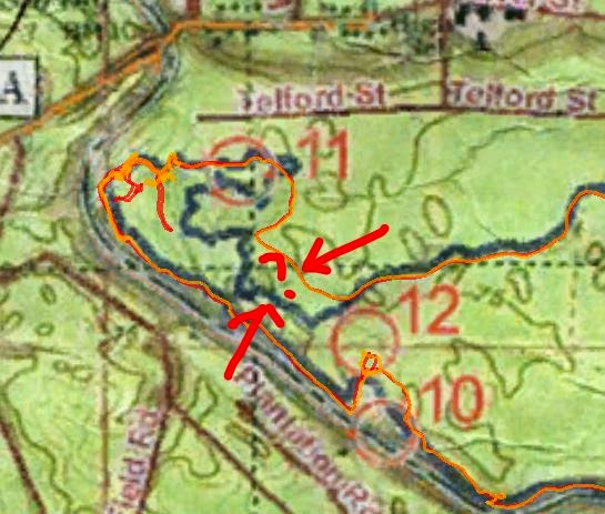
It had gone nightfall by this point.  The cooler temps were of great welcome.  CP11 immediately shook us off.  I felt like I had done a great job following every turn, but then as our GPS confirmed, the turns didn't follow the map's blue trails.  I kept trying to find an east-to-west U-turn that had a 40m diameter (near CP11).  Either we got derailed off into another trail, or the blue lines didn't exist anymore.  Lots of teams gathered up here, looking for it.  After spending quite a lot of time on this one, we called it off.


The rain-heavy clouds passed over our heads and released a torrential downpour as we biked over to the 2nd orienteering section.  Visibility was at best 10ft, and as lightning flashed the dark night up, cracks and roars of thunder followed, some very close to us.  I had visions of trees falling over on us, it was that close at times.

The rest of the biking controls didn't give us troubles until CP17 and 18.  On control 17, I just didn't measure the trail length correctly, so we ended up looking for it in a few wrong areas.  We eventually found it.  Heading to CP18, we led a pack of teams too far and then followed it back to find the correct trail.  But by then, the other teams lost faith in us, had already separated from us, and were still trying to find it.


With CP11 eating away at us, the only control we had missed so far, we decided to bike back to its location, except try for a different attack that started at the trail head.  I wanted to go west from the trail head a pre-measured distance and then bomb down 150m to find it.  Telford St. did not exist though, not even a hint of trail, so we definitively called it off.


Boat 2
After finishing the biking section at the main TA, we walked off towards Stephen TA to start our 2nd canoeing leg.  There was no shine of a moon this night.  It was completely dark.  The only help we had was a slight glow from the canoes ahead of us.


Trek 2
I used the monotonous moments during the previous canoeing leg to strategize something for this trek portion.  Just one look at the map and I could tell this was going to be our toughest, navigationally.  It became apparent that there were missing trails on this map.  I had in mind to call off some controls here, since it would be an uphill battle without the extra notes.

We did find the first few controls fairly easily, and with the pack.  We generally do not like following packs, since it doesn't really teach us much, so as we headed towards CP26, I erred on the side of caution and led us south in a wrong location just to rule it out, which separated us from the pack.

As we headed for CP27, I told Nate this would be a "hail-Mary control, with a 5% chance of me finding it."  We didn't find it, but my route of getting us there, while finding CP36 first, put us almost on top of the control without seeing it in the night!  The clue was some abandoned biking trail, but it was all pretty overgrown out there.  Lots of time was spent here.  This one demoralized the team, and I could sense us losing focus as we mainly walked it from here on out.


CP29 surprisingly took us a long time to find, so we skipped CP28, which looked like it branched off a missing trail we had forgotten to copy again.  With the rain occurring overnight, a couple of us experienced some debilitating chaffing while we walked it back to the main TA.


Bike 2
After debating the physical conditions the team was under, we decided we could easily pick off two more of the closest biking controls on this leg before ending the race.  They were pretty fast and easy to locate.


Conclusion
There were a couple 'firsts' for us in this race, but we wanted to try it out to see how we could cope with it.  As navigator, I was not the primary map planner.  Therefore, I did not know how crucial it would be to copy the supplemental maps down onto ours.  For the most part, we didn't have time.  It proved critical, and it would have been just as important if we were navigating in the day.  From here on out, I think it's pretty certain that the navigator needs to do most of the map planning.

For 18hrs length of race, I don't think we trained enough as a team compared to our other races.  Coming off a high at the Atomic 30hr, we probably dismissed this 18hr as something easy, so unfortunately we fell short of our expectations as we finished lower mid-pack.

Hien Nguyen (left), Nathan Whitaker, Tim Cowan