
ominous clouds enhancing the effect of our cramps during hour 7
We were all relieved to see forecasts not dip into the 30 degrees F heading into this race (like they were last year). We've been hitting up the FLO events in an effort to continuously improve, but our bigger goal in mind is the ultimate of races, the Atomic AR in May.


race map and instructions


Trek 1
The race started out with a prologue on foot and then on bike. We took the route to the north along the beach of Lake Louisa to get to CP1. We met half of the other racers cutting through the woods for a shorter distance as we neared the roundabout circle near WP1. Instead of relying on my plan of precisely finding WP1 and then shooting to CP1, we followed the mass crowd into the woods, thinking the chaos would eventually lead us to CP1. That didn't happen, and not only that, half of our team got separated and we spent 13 minutes shouting and finding them. CP2 and 3 were easily found with the aid of highly detailed FLO maps.

start of the race

Bike 1
We transitioned into bikes and immediately missed the first right to get on the direct road to CP4. We did not lose too much time as we took the next right that led us right back on. We rode to the point where we were immediately south of CP4, attacked directly north and found it.


CP7 was in the same spot as another CP in the Bubba Goat race a few weeks earlier.

To get to CP5, I measured 60m from the man-made object on that trail and attacked in.

CP6 was 500m from the intersection before we had to jump into the woods to follow the line of palmettos.

CP7 was in the same spot as another CP in the Bubba Goat race a few weeks earlier.
Canoe
Last year, we paddled through the massive Lake Louisa in frostbiting, choppy waters. Conditions were so bad that most teams ditched the canoe and ran alongside the lake to gather the CPs. This year, race director, Manny Otero, put us on a lake that was only about 1km wide. It takes us about 10minutes to paddle 1km, depending on wind conditions. In an 8hr race, how do you make the paddling segment last about 1/3 of the race when the lake is only about 1km wide? ...by having us go back and forth a mind-numbing nine times. In some places, there were CPs not too far away from each other, ensuring that accurate bearing measurements were critical.


Once we arrived at Dixie TA, we were given a set of instructions to follow. From the end of the dock, shoot 89* and paddle for 1056m. It would lead us into the opposite side of the lake. As sharp of a bearing as I tried to shoot from the end of the dock, there were no CPs to be found once we arrived over. We took note that there was another CP about 100m to the left of us. Nate and I convinced ourselves that 100m could be a margin of error, given our 1km paddling distance. We punched it, noted #58 on the punch to use as a reference for our second CP. Go for 955m at 196 degrees.

reference sheet

Nate and I both shot bearings on the second one. Both of us had slightly different markers in the distance, so we decided to split the difference down the middle--a technique we would use for the rest of paddling discipline. As we headed over this time, we took note that there was a CP about 100m to the right of where we shot it. Again, we punched it and chalked it up to margin of error.


We referenced #61 at the control point to our legend of instructions, which told us to go 904m at 12 degrees. The third CP was attached to a branch that was overhanging the water. This one gave us the least amount of questioning.

shooting bearings into the distance

Reference #34 told us to go 771m @ 212*. As we got nearer, the CP was just about in the middle of where Nate and I split our bearing shots. We saw Good'Nuff heading away from the CP after punching it. This was supposed to be our fourth CP. Hmm...something wasn't adding up. Either we were going fast enough to keep up with the 2012 champs, or we were way out of whack. Well, you can bet it was not the former. Suspicions started to cloud our thoughts. There was no way we could have kept up with Good'Nuff. Regardless, there were no other clear CPs nearby, so we punched it.

crossing paths with Good'Nuff in pink

The next set of instructions had us going 862m @ 48*. As we headed over, AGAIN, we noted a CP about 150m to the left of where we shot it. This time we had a hunch that we had already punched that one, so we stuck to our original bearing. Once we hit shore, we jumped onto land and scouted the area. No CPs to be found :( There was nothing left for us to do but go to the control that was 150m to the left of us. We got there and sure enough, it was the same damn overhanging branch--the same CP two punches ago. We punched it anyways. It had the same punch pattern as a previous punch. This confirmed our screwed up situation.

we saw this overhanging branch twice :(

We had no idea how they were going to score this section. There were two monstrous bike and foot portions left. Instead of doing one more iteration of paddling out and back, we decided to call it sooner than later, and end our canoeing now. If they graded it exactly, we had a chance of receiving zero points. It was the right decision for our team, so we headed back to the TA.
Bike 2
Florida is "Land of the Sugar Sand," as Greg Owens put it at the race meeting.

Conditions were pretty brutal for biking on this portion, although I still say the Turkey Burn of 2012 was the ultimate of biking brutality. All CPs on bike were pretty easy for us to find, except that we do not know if our route choice was the absolute quickest way.
We went clockwise on the southern loop and then counter-clockwise on the northern loop.
CP27, 28, 29, 30 and then CP 32, 37, 36, 35, 34, 33, 31.

Greg's battle with palmettos. He insists he did more damage to the palmettos than they did to him.

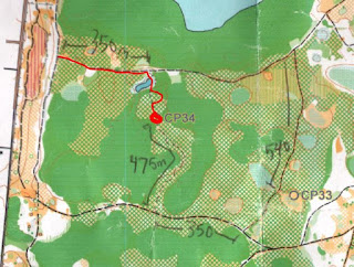
At CP34, we were told at the race meeting that there were no trails leading down into it, but there was a trail leading up into it. I determined that we should stay safe by attacking from the south, but that did not prevent Nate from dipping in from the north side. We found the mapped lake to attack from, which was pretty weak and low on water level in real life. Equipped with new FLO skills, he led us into the woods, followed the palmetto border, which got us into the vicinity, but Brian was the one with the hawk eyes, who spotted it a whopping 200m away!

Nate and I wanted to skip the last CP31, as it was the least bang-for-the-buck, but the team voted to clear the bike portion on pride. There were two areas where I misdirected the team on the wrong trail, but that probably costed us only 10-12 minutes total.
Foot 2
At this point, we had about 2hrs to go and a massive foot section. Nate is my navigator in training, who's been great to bounce decisions off of. He calculated that we had to drop several CPs off in order to make the loop around the lake, so right off the bat, we changed our plans to collect CP26, 17, 20, 22, 23, and 25, in that counter-clockwise order, while dropping the four outer-most ones. This route took us on a loop around a lake, so once you committed, there was no returning until you completely circled the lake.

some cool scenery we didn't stop to enjoy

They were all easy for us to find. Over the months, we have grown to fully understand the fundamentals of orienteering through Pangea and Florida Orienteering and our sharpshooting this day was showing it. These would have been pretty difficult for us to locate last year. During this race, however, we did not ever get the "oh shit, we're lost" moment at any time. Everything was methodical and kept track of, from distance gauging to time keeping.
On this route, there was a four foot rattlesnake that darted across Greg and Brian's path.
On this route, there was a four foot rattlesnake that darted across Greg and Brian's path.
The biggest challenge on this portion was trying to manage our crippling cramps. It forced us into a mode where we tried jogging for so many minutes, followed by walking and repeating. At CP20, we still tracked well ahead of the time we had calculated to finish on time, which we did, with 27 minutes to spare.

team Canyoneros - Brian, Hien, Nate, Greg (left to right)

Our GPS route:
No comments:
Post a Comment