Tuesday, June 2, 2015

FLX - Blue Ridge AR, Elite 24hr


There were about 60 teams racing this year, between the Sport and Elite division.  This was my fourth year racing in Blue Ridge and it's the first year there was absolutely no rain--this was extraordinary! EA Sports had an army of three teams representing.

Matt Rolfe (left), Jonathan Wolverton, Tim Cowan, Russell 'the Muscle' Barton, Brian Ruth, Greg Watson, and Hien Nguyen (me)

We had booked a cabin not too far from downtown, but still on the top of a mountain, where the driveway seemed like a steep 45 degree slope.  The night before a race is always a mad dash to sort gear, but we ended the evening with some good old fashion home-made grilled food.


The race started on bike in downtown, both Sport and Elite teams launched at the same time.  Russell felt the wrath of the uphills on the bike, but after a good warmup, he was back in cruise mode.  We continued biking into the wilderness from that point, picking up a couple controls off the single track biking trails before transitioning to foot.  The foot portion had a relatively quick orienteering section.  From there it was back on bike to pick up several more controls.  The landscape was scenic as usual.


CP17 and the 600ft Mountain Climb
In our second trekking leg, it was taking too long to find each control point (about an hour each for CP 11 and 12).  The trails weren't really tracking on point to what was mapped.  Brian's legs were screaming and locking up so this, coupled with mapping issues, I determined we needed skip a handful of controls on on this portion.  We got to a junction which was a great attack point to CP13.  We could not locate this one.  Many teams were searching for this and after spending too much time on it, we called it off and moved onto CP16, along a creek.

I was getting suspicious of the illustrated trails on this map, so what better than to find CP17 by taking a direct bearing to it from a known location?  That's exactly what we did.  We had a known point after finding CP16, so we took the brutal 600ft climb to CP17.  After missing CP13, I was motivated to keep an even straighter line this time.  The journey up there was measured out to be 700m long, as the crow flies.  It was probably 1200m as our legs saw it on the ground, with all of its ascents and descents.  700m is not a length that I like to take a straight bearing to in normal circumstances.  The degree of error staying straight on that path to the end is ridiculously high.  But the alternate route of staying on a trail was not even debatable--it was too long.  So straight we went.  Our feet turned into mush going up this terrain.  I did more damage traversing up on to this control than the entire 72hr Sea2Sea AR altogether.  As we got nearer, the angle of elevation got even steeper, forcing us on all fours and pulling each other up.  Amazingly, my direct bearing got us within a mere 5-10m of the control!  Greg's eyes lit up and I never saw him run up a steep wall of mountain faster than this one as he headed over to punch it.


location of CP21


Hien Wrecks Down a Rocky Mtn Road
We had been walking our bikes up to collect CPs 22-24 and opted to skip 25.  The trails leading to it was a continuous climb.  At CP24, I had preached about keeping things safe on the way down and that we didn't wanna sabotage what was a pretty good race up to this point.  Not two minutes backtracking downhill, I took a nasty wreck.

We were riding our brakes downhill, but I still tested how much speed I could carry and it was much more than controllable.  At some point, I had a decent amount of speed, saw two big rocks in my path and couldn't avoid them.  I narrowly dodged one but nailed the other which launched my bike in the air.  On the way down, I landed on two wheels, but at a slight angle, and the speed proved too fast to catch.  My body flew completely over a now turning handlebar (picture E-Honda's flying headbutt from Street Fighter).  I think my right forearm landed first and took the brunt of the impact.  Then my head crashed into the rocky trail as I saw sharp stones an inch away from my face.  My right side continued the momentum down.  I turned into a rag doll, flipping once, unable to do anything as I waited for physics to stop my 145lb body from sliding down any more.  There's a reason bike helmets are mandatory gear.  My face came out unscathed and my head didn't even hurt from the crash.  If I had no helmet, we'd probably have pressed the SOS button on my Spot Tracker :)

When all had stopped, I sat up, understanding something epic had just happened.  "Did I get this on GoPro??" was the first thought.  I took my helmet off, which had done its job alright.  No, I had not!  I quickly turned it back on to witness the aftermath.  I suffered some nasty skin tears along my forearm and hip, as well as some big deep bruises on my ribs and legs.

My crew spent 15 minutes bandaging me up, and after getting cleared by a racing team of 3 doctors that were coincidentally traveling by, I got up, made sure I still had range of motion in my body, and commanded we keep racing!


3.5hrs Lost in the Mountains
As if my wreck wasn't bad enough, we entered into an off-road trail that was supposed to lead to CP26.  Here, we met up with our other team EA Sports.  We bike-whacked over falling trees almost every 50-100ft.  It was extraordinarily slow-going.  The trail was an unkept single-track trail, if you could call it that.  Somewhere along the way, we got diverged south of the mapped trail.  None of us recalled any intersections or forks in the road before being lead astray.  Unfortunately, my mind was on my arm for the beginning portion, where we were still going the correct east direction.  Sometime an hour in, I checked my bearing and we were going northwest...and then southwest, and then east, and then repeat.

We debated bailing back out, but after an hour in, we had hopes that pushing forward would eventually lead us out somewhere, where we could re-calibrate our location.  It was great to meet up with one of the USMES military teams with the same thinking.  This team was hardcore to the bones, as they had been feeding off the creek water and eating snails.  After running out of water ourselves, the creek water was sounding pretty tasty.  One hour turned into two.  Two turned into three.  We stopped a couple times to try to find our location with the use of altimeters and creek identifications.  No one was confident, however.  These 3hrs lost proved fatal to our competitive contention.


Mountain Woman Detains Us With Revolver
The clue to CP26 was "Trail and Creek Intersection".  We finally ran into an area that resembled these clues.  No controls showed up here with a massive hunt, so we crossed the creek and continued down a red-marked trail, which suggested would be more used by the public.  In the pitch dark night, we spotted a dim light far away.  Civilization!

The morale lit up!  We kept following the trail towards the light.  As we got nearer, dogs started barking.  We're finally near a paved road, at last!  Then we heard the shrills of a lunatic-like, jilted woman.  "GET DOWN HERE NOW!  ALL OF YOU!  YOU ARE ON PRIVATE PROPERTY!" she screamed.

"We're lost ma'am," one of us replied, level-headedly.  "Perhaps you can show us to a road, and we'll be happy to leave."

"HOW MANY OF YOU ARE THERE?  ARE THERE ANY MORE?  GET DOWN HERE NOW!" she continued.

As we got off the single-track trail and onto her driveway (no where else to go), she ran into the house and grabbed a revolver.  Sure enough, she could shoot us all on the spot.  We were on her private land.  She continued berating us for being so lost, which didn't take much to figure out, pistol in-hand and waving it.  We kept our cool and stayed calm and collected with our responses.  That tinder could spark at any time and if it did, who knows what could happen.  Once she said something along the lines of "ahhh...you guys are the racers from Pangea," we silently shook our heads, "that m**f*ing moutain b*tch knew all along."

This marks the second time we've been shown the gun in Blue Ridge, both times when Brian decided to race with us :)  The first time was from this guy:


A couple nervous laughs there and we bolted off faster than ever.  We didn't know where we were, but her directions got us to Aska Road.  At that intersection, we finally found our way and immediately headed to Dial TA, cutting off the rest of the bike control points.  We were well past our estimated time of arrival to the canoeing portion.

Luckily Tim had his watch recording the route the entire time, so as I reviewed this GPS record afterwards, this is what I pieced together:

(click on this for a bigger view)


Night Paddle
The Dial TA was located at a small family-owned restaurant.  We refueled here with all of our EA Sports teams and discussed strategy with the remaining 8hrs we had.  I also bought some more medical supplies from their store and took care of myself some more.  One of our EA teams wanted nothing to do with the paddling at night, with potential rapids, so they decided on skipping it and biking straight to Sandy Bottom TA to start a trekking leg.  I knew we weren't anywhere near competitive anymore, so I convinced my team to do the first canoeing portion just for the experience of night paddling in rapids.  They agreed and it turned out to be better bang for the buck than any other leg we've been on up to that point.  The water was completely calm and the water depth pretty shallow in some areas.


Night Trek and the Mad Rush to the End
This was the part of the race where time was ticking and you knew it.  Everything you did had to be calculated.  I worked backwards and calculated 3hrs to leave for biking back to downtown and perhaps picking up a few biking controls along the way.  3hrs was safe to assume.  So then we were left with 2hrs to do this trekking leg.


Every control was precisely measured on the clock and future ones estimated.  We averaged finding one control every 30min on this leg, ultimately finding four, and headed back to the TA at precisely 6am (3hrs left).  Brian and his eagle eye during the day proved incredible night vision performance as well.  He was spotting controls so far away it was like he had night-x-ray vision.

On our journey back to downtown, we had a little time to fit in CP50, which was not too far off of the main Aska Road.  What seemed easy took us almost an hour to find after 4 or 5 attempts.  Optimistic Brian wanted to find more, but my calculations couldn't afford it.  That guy, full of energy, will have to wait for an expedition race in the future to satisfy his adventure race cravings.  On the flip side, I counted 40+ times he day-dreamed of beer during the race.  He would finally get rewarded soon.


After finding CP50, we dashed back on Aska Road.  This road will tear your legs uphill and reward you with the fruits of 45mph rides downhill.  Along our ride back, we noticed Greg was missing behind us.  When you're flying at that speed, cutting through the wind, you cannot hear anything, not even cars coming up.  We stopped and braced for the worst.  A minute later, Greg came riding down the road to us, noticeably shaken.  He described an incident of a car almost clipping into him, where he had to automatically veer off the road and save a death wobble in the grass.

The race ended as we coasted back to the train station in downtown where the adventure began 24hrs ago.  We had 17 minutes to spare.  I will say I miss the 30hr length of previous years!


Cruising at this speed down a road with a taco'd bike wheel is a little nerve-wracking!  But the other guys were passing me!


Conclusion
The race was an awesome experience for all of us, with memorable stories to be had.  Russell Barton was the newcomer to a race of this length, having only done 8hr races at most, but did great with my two month rigorous training camp I prescribed for him.  We made excellent use of our strengths and weaknesses as a team.  When one guy was hurting, we rotated strenuous jobs around to the stronger one.  Everyone had a positive adventure-minded attitude that kept the spirit high at all times.  Blue Ridge always gives me challenges as a navigator in the mountains, but I'm learning more and more every year, and I took a lot away from this one to get us ready for the USARA Nationals later this year in Kentucky.


Tuesday, March 10, 2015

FLX - Sea to Sea AR, 72hr Expedition (Day 3)

(continued from Day 2...)


One of Wolverton's knees was flaring up on the super long bike ride to Fanning Springs.  We did as much as we could to help out, including a tow.  Heck, this is the most biking any of us have ever done in one event.  We would finish the race traveling 360km (223 miles) on bike alone!


Canoeing and Hallucinating on the Suwannee River

The evening started setting in again and nightfall made its way through.  At Fanning TA, we were treated to hot chocolate and hot dogs.  After days of eating gels and sport beans, this was top notch gourmet food.  Canyoneros II was hurting pretty badly now and pondered efficient ways to get back to Cedar Key.  We spent a good amount of time measuring distances of different options, and discussed whether to brave the the next 18 mile paddle with them.  It was either a 4hr paddle to potentially grab four controls or a ~2hr bike ride for no controls.  We ultimately decided on paddling.


Somehow temperatures were once again forecasted to be in the low 40s for the night.  I had mistakenly miscalculated when we would receive gear bins again earlier in the day.  I had no jacket and had to borrow a headlamp from Tim.  We had no issues finding the first control upstream.  Downstream was fast, but the current fizzled out after a few miles.

During this entire race we had only had 2hrs of sleep, so Nate and I passed the monotonous paddling time by describing what we were hallucinating at the time.  We saw lots of people in these lake houses, hosting party after party.  We knew all of them couldn't have been partying, but at one point, one of the distant houses had people talking to us and we were holding a conversation with them.

Around river bends, the tree silhouettes turned into abominable snowmen holding freaked out cats.  Every now and then Nate would halt the entire canoe bracing for an impact that was not there.

After counting river bends and identifying a lit up disco ball that rhythmically spun circles in the forest, I found a good attack point to CP78, "Catfish Hotel".  "What are you talking about?" Nate wondered as he dug deep to try to figure out if I had lost it in the head.  There was a metal dock that I had Nate park our canoe for me to run up.  I ran all the way to the parking lot at the end of it, where there were more canoes.  I browsed the area and couldn't find any hint of a hotel building and returned with nothing.  Upon returning, I couldn't stop shivering.  Wolverton noticed and handed me an extra tshirt and a do-rag to put on--all the extra clothes he had left.  (After reviewing Google maps post race, apparently "catfish hotel" is the name of a pond).

With the failed attempt at finding a "catfish hotel", we continued down the river and tried to find the next two boat ramps that hosted two more control points.  I don't think we went down the flooded trail far enough at "Usher's boat ramp" to locate the CP.  Now everyone was starting to experience pre-hypothermic symptoms.  Unmotivated, we didn't spend too much time trying to find the two boat ramp controls here.  Time was against us and all we wanted to do was get to the next TA in hopes they had a campfire.  We spent the next 15km paddling non-stop in an attempt to keep moving and generating heat.  It was as though the team mood quickly shifted to throwing in the towel--no one spoke for the rest of the paddle.

Ultimately, we made it to Fowler's Bluff TA and there was indeed a campfire!  We nearly jumped into the fire itself.  The thawing legs and arms felt so nice!  And gear bins!  We were able to get fresh new clothes and jackets!  Giving up was out of the question again :)  As much as we fought the the urge to go against our goals, it was very difficult when true survival mode kicks in.


Disorienting Night Biking

Our two EA teams parted ways for the final time at this transition area.  One needed more rest and recovery and the other was ready to get it over with.

We had a huge bike orienteering section up next.  It was described as fast biking and it sure started that way.  The first control was quick and easy, but then we made failed attempts at the next three.  However, I believe we were right on top of the control, but just couldn't see it in the night very well.  Nate and I were getting extraordinarily sleepy.  After this many failed attempts in a row, in the dark, we bailed straight to the next transition area, Scrub TA, where we decided to gather the best-bang-for-buck, final CPs to end the race.  Two legs of race left, one on bike that had us traveling through the entire city of Cedar Key, and another canoe leg that had us paddling out to a historic island right off the key.  With the end in near, Nate and I turned on beast mode and left speed trails behind us.  It was surprising to see that we had averaged our fastest biking speeds on the 3rd day.  Also worthy to note was that our ass chafing had gotten so bad on days 1 and 2, but somehow the body adapted and it did not feel so bad on day 3.  Don't ask me how?


The View at Cedar Key was Breath-Taking!

By coincidence, we had hit Cedar Key right when the sun rose.  What we saw blew our minds away!  We were brought back in time when explorers tapped into the primitive lands that Florida offered and saw the natural beauty that surrounded it.


the race ends on the Gulf of Mexico


Tim and Wolverton made their way back to Cedar Key not too long after we did, collecting a couple bike controls and the city CPs along the way, and we met up again.  It was great to see us all cross the finish line on our own power.  We had experienced so much, in so little and so great of time.  You couldn't have asked for a better adventure with the undeniable highs and bittersweet lows that accompanied the race.  And thus the mighty and epic 72hr journey ended.

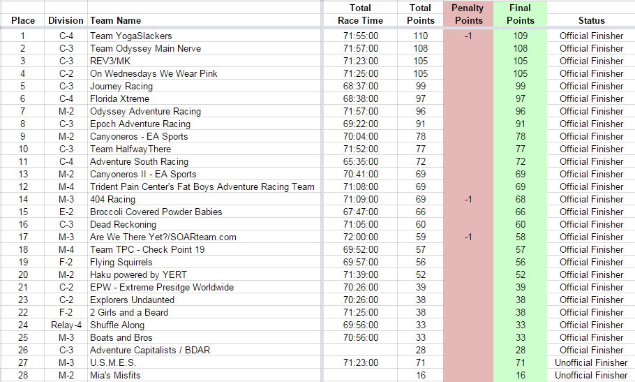
As it turns out, both teams scored high enough to qualify for competing at the national championships in Kentucky (2nd and 3rd in the all-male division)!  This exceeded our expectations and we indeed will be competing at the national level in October!

Through this Sea to Sea AR, we have also raised awareness and $3400 for the Wounded Warriors Project to help injured soldiers who have served the US military.


FLX - Sea to Sea AR, 72hr Expedition (Day 2)

(continued from Day 1...)


Rice Creek TA Trekking

The sky was lighting up again as we made our way to Rice Creek TA.  We were told they cancelled the following paddling leg, as the race directors determined they needed to move the teams west quicker.  That and people started hating the paddling legs haha.  It was a great relief, since we were planning to can that leg anyways.  One...it was paddling and we started hating it too, and two...I had predicted many of the controls there might be pretty tough to navigate to.


Up next was a trekking leg.  The sky was overcast and the environment was like a tropical jungle with lots of swamp.  It was one of the coolest sights!  We began by latching onto an incorrect set of trails.  This burned a an hour or so before we found the right one.  Once we lined up the trail map to ours, we immediately set foot to find the CPs here fairly easily.


Wolverton climbs over fences

At Backwoods TA, there was a bonus trek course.  We had to plot UTM coordinates for five control points.  This was the first time I had to plot them, and there was another team nearby who noticed my difficulty, so they graciously gave me tips.  We cleared this section pretty fast, utilizing a 60 second shuffle, 60 second walk methodology.


There was a long bike ride to the next stop at Newnan's TA.  We easily picked up a handful of controls along the way.

Somehow, Tim had managed to get a hold of a 5-hour energy shot, I think from Nate's bin.  It supercharged him so much he took navigation and bolted forward on bike at a pace that maxed us all out!  I'm not sure he realized it at the time until we told him about it afterwards.  But hey, he was hitting all of his points, so we left him at it.  Once we got to Newnan's TA by nightfall, Tim proclaimed, "I feel like the race just started!".  Those 5-hour energy shots had some serious kick to it for him.


Tim Goes into Hypothermia

Newnan's TA was the start of a giant swamp, and CP47 and 48 were situated deep in it.  This place had massive cypress trees everywhere, fallen over, uprooted, you name it.  There were also plenty of cypress elbows, aka death stumps.  We saw plenty of giant snails, most of them the size of a fist.  So in the night, we made an attempt to shoot a 400m direct bearing to CP47 but could not find it.  We found only a two CPs in this entire trekking section before Tim started spiraling into hypothermia.  Nightfall brought in low 40s temperatures.  When Wolverton and I saw him convulsing like someone with Parkinson's disease, we immediately cut off any progress, he busted out the emergency blankets to wear under the jacket, and we all went back to the TA where there was a campfire.  As we stumbled back, Tim's competitive mindset forced him to utter, "Hien, give me six 5-hour energy shots and I will finish the race!"  Adventure racers are a crazy bunch alright :D


Wolverton Catches on Fire!

It was apparent everyone was dead tired, cold, and miserable on this second night.  We made the call to warm up at the campfire and then catch some sleep in our sleeping bags.  Tim and Wolverton slept by the fire since they didn't have a sleeping bag.  In the middle of the night, Wolverton deliriously wakes up to the horror of people beating him with clothes.  "WTF is going on," he thought.  He was on fire!  A campfire log had fallen on him and burnt his clothes and racers nearby were trying to put it out!  Seeing this, the race staff decided to lend them both a sleeping bag and a spot in the staff tent.

Nate and I woke up after two hours of sleep.  It was a significant recharge to a heavily degrading team.  We had only gotten two controls in the last 6hrs.  But now we were ready to get back to work.  We touched basis with Tim and Wolverton, and parted ways with them.  It was sad to finally separate the two EA teams after sticking together for a solid two days.

The morning brought optimism.  Ron Eaglin was out and about, and offered to lead us and a few other teams to CP47, which we missed that previous night.


The Windy Paddle

We then transitioned to canoeing, where the boat launch was in the same giant swamp we had just trekked over.  How was there a channel that existed there?  What we saw the previous night was a giant swamp with several streams of water here and there.  I'm not sure I recalled a channel that led from the transition area to the lake, but in the morning after some much needed rest, it was clear.


Canoeing on the lake was very pleasant at first--the water was as smooth as glass.  That is until the sun rose and brought in billowing winds to the lake.  We DID NOT wanna capsize on this lake in really cold conditions.  There were two control points along the way to the next stop at Kate's Fish Camp.

Once there, we transitioned onto foot, where Nate and I picked up one trek control before calling the rest of the other controls off.  Teams reported how tough that section was, both in terms of navigation and bushwhacking conditions.  Nate's knees were an infected mess, swollen, bloodied and battered by thorns in previous days so he was in little shape to beat them up some more.  So we walked back to the TA again.  There, I wanted to go light, so I opted not to pack jackets and head lamps.  On the flipside, Tim and Wolverton had banked some more sleep and skipped the paddle section, and decided to ride their bikes quicker to the other side of the lake instead, but for no control points.

Amazingly, both of our teams re-united at this transition area.  We felt great synergy again.  Tim and I were swapping navigation roles, where one guy would have one set of maps viewable on the bike map board, and the other would have the next set of maps, seamlessly planning and transitioning without a hiccup.  Nate and Wolverton also did a fine job of hunting/punching the controls.


(continue onto Day 3...)


FLX - Sea to Sea AR, 72hr Expedition (Day 1)


The Florida Sea to Sea AR was the most challenging journey in our adventure racing history.  It spanned an astounding 72hrs across the entire width of central/northern Florida, touching both ends of the coast.  Two Canyoneros EA Sports teams braved the challenges that stood ahead with hopes that at least one team would qualify for the National USARA Championship in Kentucky.  The usual suspects of Nate and I would race with another veteran racer and excellent navigator, Tim Cowan, and newcomer Johnathan Wolverton.  Wolverton, an ex-Air Force and ground troop, had two other races under his belt, a 6hr and an 8hr.  What better than to keep increasing those numbers and jump to a 72hr next?  He had no idea what he was getting into, but we needed someone with a proven tough-as-hell mindset, someone who had stared Afghanistan in the face before.

Johnathan Wolverton (left), Nate Whitaker, Hien Nguyen, Tim Cowan

Florida Xtreme Adventures' race directing team put on an incredible race that had a wide variety of racing elements, from lengthy distances, tough night navigation, bonus courses, food/campfire TAs, trivia control points, and a sweet Cedar Key ending that had us exploring the entire Cedar Key city and historical island there.  Major props to them and the volunteers.


The day before the race, we browsed Cedar Key looking for as much food as we could eat to fuel up for the next 3 days in which we would be in a constant calorie deficit.  Cedar Key is a quiet small town with buildings that appeared survived the last century or more.  A race meeting was held in the creaky town library.  We received our passports and maps for the first half of the race and then proceeded to load the Uhaul trucks with our bikes and paddling gear.  We spent the next couple hours eating microwavable ravioli and planning the maps in our hotel.  We also decided for a fairly early cutoff time to go to bed, banking on the more crucial aspect of sleep.  There were just too many maps (21 maps for the first half of the course alone) to strategize everything so we were determined to rely on spontaneous decision making and measurements.


The Start (Day 1)

The next morning, we were bused to Flagler area along Highbridge Road, where we started off on a relatively quick jog to collect four control points (CPs).  The sun was beating down on the day and temperatures were rising quick, as it was forecasted to be the hottest day of the race.  This was Nate's day to survive, as the Englishman's got a history of easily overheating.  We did what we could, including slowing pace down to manage this.  If he could survive this day, it was assumed the rest would be smooth sailing for him.

race starts on the Atlantic Ocean


Bonus Technical Biking

From there, we jumped into canoes and paddled our way up Bulow Creek, biked down Bulow Ruins, and back up John Anderson Hwy to start a bonus technical biking section.  It was a sweet 6.2 mile set of trails that I had no idea existed there.  We picked up five(?) controls here on the 'easy' route.  Any other day I would have loved this area, but this section took a solid 2.5hrs to complete and took its toll on the team.  Nate's heat was noticeably building up and Tim was getting pounded on the technicality.  We constantly fed Nate NASA water to manage this.  Even with steam coming off his head and cheeks as red as fire, he would mutter "Hien, I always shake this off."


Nate the CP Sniffing Dog


For CP14, we had a long pre-measured distance to travel before attacking into the control.  I couldn't find any other nearby attack points to minimize the measuring error that would occur with longer distances.  Our best bet was to send Nate, the hound dog, to lead us into the forest to hunt this one out.  He didn't fail us.  It was amazing, as this was one of many others we relied on him for.  The objective was get Nate within 200m and he'll sniff it out, always :)


Evening was setting in.  We found several more control points in the city of Bunnell, as we made our way to the next section, another canoe segment.


Canoeing over Fallen Trees

There was a tight channel that poured into the main river at Black Branch TA.  Along the way, there must have been ten areas where a tree or two fell over the channel and forced us to plow our muddy canoes over them.  The first few were really cool, as it gave us a great sense of adventure.  It was nightfall, bugs flying everywhere, and no one else out there but lunatic racers.  We would paddle up to the fallen tree(s) and then decide whether to portage our boats on the sides of the channel, or just flat out haul our canoes over the fallen trees.  We saw snakes, frogs, and many spiders here.  At one log, where we knew we would need to exit the canoe into the water, our flashlights revealed the glowing red eyes of a big gator sitting, watching us.

For about an hour on this paddle leg, I kept hearing a hissing noise coming from inside the canoe behind me. I kept freaking out and was concerned that a snake had fallen into the canoe and was hiding somewhere under our paddling bag. Eventually Nate couldn't hold it any longer and his laughing gave it away. It turns out every time he moved, his canoe seat pad would let out a little air making a loud hissing noise.  That guy...


In the middle of the paddling section, there was a bonus trek section embedded in.  There, you had until 11pm to collect as many controls as you could in the dark.  We got there pretty late, but still found three of the closest, best bang-for-the-buck controls, and headed right out with only minutes to spare.

Most teams re-converged at this point, as they tried to maximize their points on that 11pm cutoff.  From there, it was a long paddle to the next transition area (TA).


City Biking in the Night

The long paddling legs set the stage for some nasty ass chafe since you were constantly wet while sitting in the boat.  At Bull Creek TA, a couple of us were treated to a warm shower in the public bathroom facilities there.  We spent time eating some substantial food and putting on fresh new clothes before heading out.

Next up was a biking segment that had us picking up several controls off Hwy 20, enroute to San Mateo.  A couple of the controls here had you answering questions like "what is the church's name at the CP location?"  CP23 gave many teams that converged there fits.  The clue was "east side of pine along road".  No one could find it, as the trails there did not really match what was on the map.  Apparently, word was that it was only 5m from the road, but most teams were poking about 70m deep into the fields, ultimately giving that one up.  The lack of visibility in the night made control hunting really difficult.


Tim started hallucinating this night, seeing images crawling out of the blinking red bike lights that mesmerized him.  Sleepiness was dropping the curtain down fast on him.

At CP27, I had gotten so depleted of energy I couldn't even push my bike on a grassy trail leading up to the control.  All of a sudden, I felt so dead.  The team took a quick few minutes here to eat and eat, and it was just enough to recharge me.


(continue onto Day 2...)