Sunday, August 18, 2013

Pangea - Nocturnal AR, Elite 18hr


There were some great successes and some frustrating mistakes, but in the end, Canyoneros took podium for the second time ever in a mind-blowing 18hr long race that spanned across two days.


Trek 1
A short bike ride started the foot section, where we received a new map to hit 8 controls out of the 10 plotted.  Two paired-controls would equal one CP, and each pair was located almost opposite at ends of the map.  There wasn't much time to measure out distances to see which four pairs were the shortest distances, so we just grabbed A,C,E, and D, creating two loops.


The heat was definitely felt at a time when the day was at its hottest.  In an effort to conserve energy for an 18hr long race, many teams opted to walk in several portions, and so did we.  We were next to team Nature Calls at one point, who were walking just as fast as we were trotting.  Those guys can walk very fast!

a large turnout of 24 elite teams participating

Florida jungles

lots of grassy trails

finding CP C2 with team Swamp Gators - Joel Young(left), Tim Cowan, Leslie Cowan


Bike 1
A quick transition into bikes and we rode to the boat TA to pick up two more controls.  The first one was easy, but the route to the second one had us entering a swamp and crossing the murky foul-smelling stagnant water.  It was easily waist high with feet sinking mud at the bottom.  I told ourselves that we would not want to cross this swamp on the way back.  I noted a trail head near CP2 that appeared like it could cut straight east for us to return later on.


Canoe
Once on boat, I decided to skip CP3-5 and go immediately downstream.

Canoe TA - looks like monsoon season in Vietnam

Lightning struck loudly, and the thunder snapped at the exact same time, lighting up the dark skies as rain fell.   It struck so close!  Suddenly we were thinking to ourselves, "WTF happens if lighting hits this water?  We're on a silver metal boat with metal paddles!  Yikes!"  At moments like this, there really was other choice but to continue and hope you don't add to statistics.  It's what keeps the blood flowing :)


We arrived at the first control and punched it.  None of the numbers corresponded to any on our punch card.  I had mistakenly thought our punch card contained all the boat CPs, but apparently not.  We figured it would take 30min to backtrack to the boat TA and back just to get the correct punch card.  It was not worth it for us, esp. after one excruciating boat whack, so we just used the current card to punch the rest of the controls.  After asking the officials after the race, they said they would not penalize us for this mistake, so our mishap proved lucky.

trust us, there is a river underneath this!

By skipping the first three CPs, we were trail-blazers, carving routes through thick, overgrown vegetation and fallen logs in various areas along Black Water River, where we had to lift and carry our bulky canoes over.  The length of this paddling section was mind-numbing to say the least, esp. from CP6 to 7.


At CP7, I switched to a hand-drawn map that I had copied onto paper from the Google images provided at the pre-race.  Google images reflect better accuracy, as opposed to illustrated topo maps, which usually round off and omit some river bends.  My map was easier to read and it led us into CP8 really well.

glorious canoe map (bottom right corner)

Nightfall struck, which made CP9 more difficult to navigate to.  We even ran down the wrong channel of the river at one point, only to cut across to the correct one by accident.  I didn't even realize it until I reviewed the GPS route afterwards.  Even then, we made several attempts at attacking this control along the many dead-end channels.  Eventually through luck, we crossed paths with team Crew Zen at the exact location of CP9.  Had it not been for them, we would have completely paddled by, not seeing it.  It was only about 3 meters away too!

only adventure racers paddle and find excitement in rainy, remote places like this

Nate and I have paddled this Wekiva River on a previous Scar AR before, but during the night, this river looked just the same as any other river we've been on--palm trees to the sides and the occasional logs underwater to suddenly jolt our boat unstable.  This time however, the glow of our headlamps revealed red pairs of gator eyes in the night.  We must have spotted a few dozen of them on our way back to Wekiva TA, some floating across the middle of the river, but most looking out from the sides.  Mating calls were in full force as they barked away after sunset.

twilight hour - the race is only 1/3 complete


Trek 2
We were so excited to get off the boat and move onto a different exercise.  Energy was high and endurance amazing.  This leg proved extraordinarily successful in every way possible for us.  We kept a constant steady trotting pace the entire way and pinpointed every turn, every trail head, every CP.  Nate was like a radar here--incredible navigator aid.

Pangea added another CP12A at the start of the race, as to discourage people from swimming across Wekiva River on their way to the first CP on Trek.  You don't really wanna swim 200m in the night while the gators are out in full force anyways.  That's just a stupid idea.  You're guaranteed death by gator chomp.

My GPS recorder only records 8hrs, so I was selective on what to record as we ran our way back up to the Boat TA.  Historically, our night navigation has shown funny things, so I turned it on during this leg, but nothing outstanding happened--which means success!  Success indeed!  We cleared this leg in a blazing 1hr 55min, one of the fastest!

GPS route

Being the first team out on this leg, we plowed down giant structures of spider webs that were spun across the running trails.  Some were 8-10ft wide and strong as steel cabling!  It was interesting to see the many types and colors of giant spiders at the centers of these creations.  Every now and then a dragonfly got trapped and you saw the viscous aftermath of the spider injecting flesh-melting venom within its death grip happening right at the moment.  I was glad we were not on bikes where we would have flown by and eaten a dozen or two to the face.


Bike 2
It started with an pleasant ride to CP15 and 16, but this leg of the race gave us the most trouble.  I usually have no problems navigating on bike, so maybe confidence was too high.


Going towards CP17, I remember noticing a trail head at CP2 that I was hoping cut straight east to the road (so I could take the planned blue route below).  It did not.  We ended up taking the same damn route back across the swamp after several unyielding calls of "we're past the point of no return".  This time we got punished by being forced to cross not one, but three swamps with our bikes--one being neck high to me!  Bike whacking is the slowest form of transportation.  Never choose it when given roads as another choice.  I recall taking a route similar to the yellow illustration below.


From 17, we wanted to stick to our plan of clearing this portion in a counter-clockwise method, heading for CP19 next.  I wanted to head down the mapped trails to 19 (blue lines below), but trails just didn't line up according to map in that area.  We found another trail that slowly curved and headed up northeast (yellow), and I thought it was the green trail (below).  This mistake forced us to change plans and get 18 instead.  However, we weren't on the trail we thought we were, so we attacked CP18 at the wrong corner (A).  After completely clearing the area, we knew something was wrong, so we determined that heading out to a known trail was the best course of action.  Team morale was starting to plummet after two debilitating errors.  While heading east to the main road, we were relieved to find team Hunter attacking CP18.  It finally hit me and I realized my navigational error.


CP19 was a little tricky to find too.  The clue was 20m southeast of wetland.  When we got to the junction, there was no trail heading further south, as mapped.  All we saw were vast fields of palmettos.  The fields weren't really thick yet, so it was easy to travel through.  After 5min or so, the wetland revealed itself and Nate was able to sniff out the control.

CP20, 21, and 22 gave us no troubles.  The grassy and muddy ground was terrible to ride on though.  Chaffage was a problem for me.  I had to stand up and ride the rest of the way, which was like another three hours :)

Heading up to 23, I lost track of where I was on map, so we followed a series of disorienting trails.  We bailed to the main Fechtel Road at first opportunity, where we biked to the main TA and tried to enter the trail head east of there, but never found it in the night.  Two attempts at this CP and we called it off, saying we would return to it in the end from CP24, using a clearer trail to come down into.  It was obvious the long hours of the race was taking a serious toll on our thinking and focusing abilities.

Up we went to CP25.  It was a LONG ride.  I had completely run out of water and began sipping what little water Nate had left in his Camelbak.  With the mind shutting down, we followed the dirt path all the way to the park entrance.  Park entrance?  How did we end up there?

Back we went and saw the sign that said "North" to continue our route to CP25.  It was a grassy trail with some sugar sand sections.  The return route was equally mind-numbing.

Going towards CP24, we met up with team Swamp Gators, our coworkers, and found the control together.  We split ways after that and hunted down the elusive CP23.  Our mistakes on bike were probably due to not measuring out distances and constantly keeping track of the compass.  We were sure to keep on top of our 3rd attempt at CP23 and it worked.


Trek 3
At the main TA, we refueled, ditched some heavy items in the backpack (food bags and light gear) and headed out.  It was apparent we were in zombie mode as we could not locate the trail head to CP26.  "Fail fast, fail cheap" became our motto.  Plans changed.  We headed towards CP30 for the start of an inefficient route.  Chaffage was at its worst here.  It severely limited my running abilities.  I fought through it, however, to the point it desensitized.  I knew I had hell to pay later.


We went counter-clockwise, hitting 29 and 28.  The clue stated shooting a bearing off of WP28, but the control there matched our punch so there was no need to hunt.

After that, I navigated us to the park entrance.  Park entrance again...?!  "Why are we here," I asked Nate.  What was going on?  I had no idea why I led us there, but perhaps the bolded blue font on the map looked like a CP destination.  What a terrible, unnecessary ~1.4km of jogging during our wretched physical state.  We usually laugh off stupid mistakes like this, but frustration overcame us and we had no energy to laugh.

From there on out, we put every ounce of focus towards going back to the basics of counting pace, checking compass, and reading the map, as we completed one of the lengthiest races we have ever set out to do.


Conclusion
At the end, we finished finding every control we set out to find.  Our rank was third overall as we crossed the finish line, but with an hour left, there could still be teams coming in who cleared the course or found more than we did, putting them ahead of us.  We felt proud about how hard we physically pushed and did not think twice about a podium finish.

When the race time cut off, our 3rd place (1st in our Open division) surprisingly stuck as we heard our team name over the loudspeaker!  It was a spirit-raising end to a race that had us riding the highs and lows.  Our team was originally born without navigational finesse, but if there's one thing we Canyoneros can rely on, it is our constant pace, stubborn brute force, and strong mental perseverance, that allows us to make up for our mistakes.

I have to give big props to team Honey Stinger (1st overall) who were the only team to clear the entire challenging course.

Team Canyoneros - Nate Whitaker (left), Hien Nguyen

Saturday, August 10, 2013

FLO - Little Big Econ (Dash's Fundraiser)

sport course

elite course

This is a course that FLO put together to help raise funds for Dave "Dash" Ashley, who is competing in Estonia for the World Mountain Bike Orienteering Championships.  Going out of the country is something we've been dreaming of for the future.

The day started at 11am for us.  We thought the elite course started at 11am, but found out it was a mass noon start.  So what did we do?  We had to have our warm-up by doing the sport course :)

Sport Course

It took us some 34min to complete a 3.5k course.  I would report more, but there was no thrills to it.  Just a good ole fashion Canyonero-style warm-up.

Elite Course

We were allowed to strategize with the map ahead of time.  Two CPs stuck out to us as most difficult, CP50 and 51.  Once the starting line was cut, we all bolted out, some went clockwise, we went counter-clockwise, as to hit the seemingly more difficult CPs first and leave the mind-numbing jogs to the end.

After punching the first control, we cut across a stream and saw people repulse at the sight of us doing so.  They went around instead.  We've been told this is an adventure racer's tactic.  Orienteers prefer to keep clean and dry.

CP42
I pace counted to after what I thought was the sharp bend leading east towards CP42, but ended premature.  That's ok, because the feature I was looking for after bushwhacking south was a ditch that spanned west to east.  There was room for error.  We ran into it, followed it east and found the control easily.

CP44-45
The beauty of the FLO events is that we try whatever we want without the pressures of a real race.  Instead of going back out on the safer trails after CP44, we bushwhacked a straight line to CP45.  After hitting the trail near there, I thought it was faster to just jog on the trails the rest of the way, which was rather short.  The trail leading off the main road was pretty obscure, so we overshot it initially and realized quickly.

CP45-50
We could have kept it safe and followed the trail all the way towards 50, but decided to take short routes over.  There was some easy lane changes that cut the time down signficantly.  As we made our way out to the marsh near CP50, the attack became apparent as you ran along the "beach".

CP51
This control was the toughest by far, and upon GPS replay, we spent 33 minutes looking for it, 20 of which were waste.  This was the only control we had trouble with.  In the end, we were saved by Ron Eaglin and his partner.  We also met up with Tim Cowan, a coworker of ours who races for Swamp Gators.  On our exit, Tim ran west of the marsh, while we cut straight through it to  head up north.

CP47
We met up with Tim again here.

CP46
Tim decided to stay on the trails to go towards 46 after punching 47, but we trucked through swamp.  This bushwhack has taken over the award for "Nastiest Bushwhack" ever.  Once we poked into the woods, it was about 100m before we hit marsh.  We thought to ourselves, "this isn't too bad".  Then we got deeper.  It got thicker, more foul smelling, and murkier.  The logs we tried to stand on were too soggy and crumbled under us, making me crash down into its bowels of shit.

Frustration was apparent, but it was past the point of no return.  We got further and further, but the whack gave us more brush and entanglement.  We were going about 1 ft every 5 seconds, trying to clear thick vegetation in the sickest of swamps.

Eventually, we saw grounds and it was the best sight ever!  As we got out of that sticky mess, we located 46 and saw Tim fumbling out of the woods again.  Tim's a great runner, but our tactics have proven to be the faster choice so far; dirty, but faster :)

Bushwhacking is a strategy that also conserves energy and keeps you in the cool away from the sun.

CP43, 41, 37
These three were the most mind-numbing CPs to get to.  The jogs were long, the trails were in the open with the sun baking down on us.

I decided to take the slightly longer route to CP37.  It appeared to contain a more accurate attack point.  The exiting bushwhack also saved time for us.

CP35
Heading towards CP35, we met an older man, Joe, laying down in the shade beneath a tree.  It was obvious he had met his challenge for the day.  I gave him just about the rest of the Powerade I had in my Camelbak.  I was shocked he had only carried two bottles of drink with him.  After understanding he was still alert and somewhat healthy, we ran back to the finish (~1km away) and came back to recharge him with an extra bottle of Powerade I had back at the car.  He wasn't the only person(s) we saw just chilling under shade that day.  There were several others.

We cleared the course in 3hrs 43minutes and were happy with the way we found most of the CPs.  The next day I woke up with a pounding headache that felt like a hangover.  What did we learn?  For the 18hr race coming up next week, about 5.5hrs will be during the hottest part of the day.  Our original gameplan was to run those 5.5hrs at a pretty good pace in order to maximize daytime visibility.  That has since changed.  We are going to start slow and stay slow the entire race.  If ~5hrs of FLO racing got us so dehydrated, imagine going into the night in that state, with another 13hrs of race to do.  It'll definitely affect how sharp you are, mentally.

Monday, July 15, 2013

Pangea - Luminescent AR, Elite 8hr

Team Canyoneros - Hien (left) and Nate

This night race was an excellent race of redemption from our last year's pathetic performance.  Today, we finished 5th out of 14, against a strong stacked lineup of teams.  There are not very many opportunities to practice at night, so our results at last year's Luminescent AR had the excuse of being our very first night race.  There was no excuse this time around.  Night racing is incredible and challenging.  You do not have the benefit of seeing very far to confirm positioning, and if you can develop the skills required, it makes it very rewarding.

Team We Blame Javan once told us to make a lot of mistakes going to the race site so that it jump starts your alertness during the actual race.  We didn't get lost going to the race site, but we forgot backup flashlight batteries, folding tables, and even both woke up feeling sick.

race instructions

Foot 1
Here's our route for the first section.  We were the leaders to the first two CPs, as the mass crowd followed some reputable teams and overshot the wooden fence leading to CP21 (first CP).  Heading towards CP23, I inadvertently took the northern trail (A) while heading east, thinking it was the more southern trail (B).  After running down and up the north-south trail (C), and not finding the trail leading to CP23, we re-calibrated and then figured out where we were and lost the early lead.


Heading out of CP23, I decided to bushwhack west to get to an open trail, but got caught on some prickly fields of thorns, bailed out and found the trail, anyways.  I chose intersection (D) to shoot a direct bearing towards CP24.  Our sharpshooting has gotten pretty strong over the months and was pretty reliable, as opposed to going around the forest.  At night, we wanted to avoid high risk strategies.  It proved successful, as we saw many teams go around the forest (route E) well ahead of us, in an orienteering fashion, but our bushwhack proved to save even more time.


We got out of there by bushwhacking again towards the trail going down to CP25 and exited to the main road to finish the first section.

Bike 1
Nate and I had done our due diligence of studying Google Earth maps, taking guesses at where the race would be held.  Neither of of us even thought Pangea would take us out into the intercoastal waters, but they did.  This segment of the race was fast and furious, as we picked up CPs in the city, heading to and from the Boat TA.  It brought back good memories of when I was delivering pizzas for Papa Johns while in college.  I could not be lost on the streets :)


CP11 was en-route to the paved roads and as we biked towards I-95, we spent a while chasing and passing team Hunter.  Jeez, father and 12yr old son can bike fast.  Some of our mistakes are made while we follow other teams, and CP10 was no exception.  We saw another team erroneously ride to the back of the high school located here.  A couple attacks and we found the word needed for the punch, as the clue was "last letter of first word above Class of 2004."  As team Mojitos headed back up War Eagle Blvd, we again followed, but decided against it and stuck to our original plan to head south out of there.

This is where team Swamp Gators, our coworkers, joined us, upped the ante and brought excitement as we blazed through the dark hours of the lifeless city.


On our way to CP2, I accidently skipped over CP1.  The map print was so small and in the night, while biking 30km/h, it got very hard to read without the risk of ramming into a car parked on the side of a curb.

I should have measured the distance from the beginning of the bridge to the Boat TA.  The highway had a nice and large bike lane on both sides.  Despite that, we were met with angry hoodlems driving by, screaming words of disgust while hidden inside poorly pieced-together clunkers.  I recall BMW logos on a four-toned Civic with Christmas tree lights and bumpers that don't fit and are barely hanging on.  Who are they kidding?  Welcome to the City of Mims, I guess.


While cruising down the highway on the far end, we saw land and docks, and thought the launch was there.  I followed it all the way to the end and saw nothing, but then realized the mistake once I looked at the map again.

Boat


CP9->8->7->6 were obtained with relative ease.  CP9, however, made us lose some time as we docked our boat on the island nearby and scoured it.  The clue was "vegetation west edge of island".  The CP was actually on land, east of the island.

My compass must be going out of whack or something, because my bearings towards CP6 and CP4 didn't take me along my intended lines.  In the night, you can't see landmarks, such as islands, until you get pretty close to it, so it's tougher to course correct.  I also had to conserve flashlight power.  Regardless, this issue only messed us up on CP4.  During the daytime, we definitely would have seen the massive opening into Gator Creek.

We were highly impressed with our improved navigation in dark, in the water.  The intercoastal was extremely choppy, especially as you went down from CP6 to 3 in the open.  I suspect some teams portaged their boats across highway 406 as a means of a massive shortcut, both in distance and in avoidance of waves.  That'll be something we'll have to consider next time we strategize.

We headed back around 2am and there were people still fishing on the docks!

Bike 2
Since we missed CP1 on the way out, we gathered it on the way back to the Main TA.  No time lost, really.

Foot 1
My legs were cramping and I was starting to mentally fatigue here.  Nate has always been my super reliable wing man during training and racing.  He backed me up tremendously from here on out after recognizing my state by asking me relevant navigational questions.  Can't let the navigator bonk, otherwise, race is over.

racemap - foot 1, bike 2

I immediately got lost heading to CP12.  I got us into a series of loops and circles, and re-calibrated after hitting a familiar ditch to the north (A).  Luckily it was a small area only.


CP13 and 14 went by with precision and a little luck.  CP15 gave us the most trouble as you can see how many attacks we executed through our GPS route:


I honestly believe this one was not marked on our map as accurately as it could have been.  Based on our measurements, the original map marked CP15 at location F in the pic above.  We ran up and down the two trails 5 or 6 times, measured, re-measured, tried to bushwhack a direct bearing but failed due to dense shrubbery, and then finally found it with Nate's stubborn determination.  It was incredible and badly needed after all the time we spent on it.  It lifted our spirits and as we continued on, found CP16, and headed back to the Main TA.

Bike 3
Nate was sharp and vigilant.  He took on the role of time management with the last hour left, saying we needed to spend 20minutes out and 25minutes back to make it on time.  With that said, we chose the two easiest CPs to go for (CP18, then 17) and left 20 as an added contingency if time permitted.


CP18 was the first to grab, as it was the furthest.  The other two would be closer to give us better time to head back.  We pummeled down hard packed road and pinpointed both CP18 and 17 with surgical precision with my on-the-fly measurements.

The speed and accuracy afforded us time to grab CP20, which I deemed would be much harder due to the orienteering nature of it.  It was about a 300m bushwhack into what looked like dense forestry.  Nate was hesitant but with the time left, I was optimistic.  We dropped our bikes on the trail at point G, bushwhack in, and with Nate's FLO experience along my side, recognized the "south of trail" and "vegetation boundary" to find the control.  We had plenty of time left and easily finished back with an astounding 48min segment.  CP19 was left on course and it was the only one we didn't get, due to time.

Fifth place was a drastic improvement over last year's second-to-last place finish.  What changed this time around was that we usually knew when we were veering off course and always had a plan of correction.  We used our strengths to our advantage and kept things methodical and accurate.  My co-navigator Nate was highly proactive as well, not merely following what I'm doing.  We were incredibly happy with the results this year.


Stats
34.77km biking, 12.6km paddle, 14.6km run

Saturday, June 22, 2013

Bubba Goat (reverse ghost course)

We sometimes come up with the most masochistic workouts without thinking too much into the reality of things.  Today, we said "let's do the Bubba Goat in reverse" to give us a different perspective into a course we had done back in January...except today was 40 degrees higher on average!

The first time we did it, it took us 3hrs 30minutes, including a prologue.  We knew our 3 liter Camelbaks wouldn't last that in this heat, but we decided to race whatever length we could manage, with an emphasis on efficiency in route choices.

There would be no controls placed, so how do we do this?  You need the original map and a GPS recorder.  The map contains clues we can use to identify control features, and the GPS route will allow you to review afterwards to see if you really hit the controls.

CP16-14
On our way to CP14, we picked up 16 and 15 with no problem.  At CP14, we hit the first bend in the fence and shot a bearing to the control.


CP13
We trekked diagonally towards the road to cut down distance as we headed to 13.  On the road, we ran into two junctions before shooting a direct bearing to a highly visible embankment that housed 13.


CP12
Again, we cut distance down by heading to the main road at a diagonal.  CP12 was a matter of running a little bit past the trail intersection (A) and locating a marsh.  The control was at the "northern edge of the marsh."


CP11
We took what we thought would be the shortest trail to CP11.  At the intersection (A), we shot the bearing straight south and tagged whatever distinct trees we saw between the trails around us (in red).


CP10
At the intersection near CP10, we saw a line of palmettos (illustrated on map in green) that led to a mapped dry ditch.  We assumed the northwest end of that dry ditch contained the punch.


CP9
We took some diagonal lines to cut down distance to CP9.  At the trail opening (A), we shot a direct bearing identify the forest that contained CP9.  The forest had an opening with one row of orange trees that we followed to the end to hit the punch.


CP8
We followed a line of trees to exit, and then a ditch line that led to a small lake.  From there, we rounded the lake, followed a road mindlessly, only to realize we needed to shoot another bearing to CP8.  Going down to it, we checked off a 'ditch lake' to our left.  After punching, we diagonally exited to ensure cutting down on the distance, and therefore emphasizing efficiency.


CP7
It was a long jog to CP7, but the conversations we had took our mind off the grueling task.  To hit 7, we first identified the opening in the woods (A), and then shot a bearing to an easily identifiable, large depression.


CP6
Our rule of thumb for determining whether or not to jog the further trail or bushwhack the shorter distance is "3 to 1".  If the faster, smooth-running trail is less than 3 times the distance of the bushwhack, then we'll choose to jog it.  We broke that rule exiting CP7 just to see what the area here was like.  It was slow going alright.

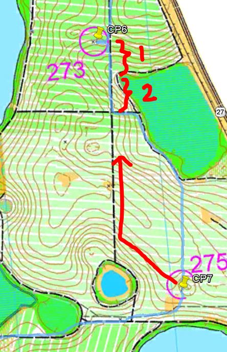
CP6 took some precise measuring and awareness of land features.  As we headed up from the 4-way intersection, the CP was twice the distance of when the vegetation border ended to the right.  The topographic lines also indicated we would be going uphill, and not yet hitting the peak of elevation before cutting into the woods to find this man-made object (a water pump).  After cutting in about 25m, it was easily visible from the distance.


CP5
We followed the fence on the right side, hopped the fence after the trail ended, and poked back in after the lake ended.  As we headed alongside the lake, we looked far into the distance and identified the cluster of trees and clearing at the northern border of the lake (CP5).


CP4
Look how straight our bearing was from CP5 to CP4.  The terrain was very slow going and the heat was killing us here.  I was really wanting to sharpshoot directly to the intersection near CP4 (A), and we were super close--only 35m away on a 1100m whack through that dense shrubbery.  As to the decision of whacking vs running the longer route....the whack didn't fulfill our requirements of 3 times the distance.  The whack was 1100m, the run was 2000m (B).  If we were fresh and the weather was much cooler, the run definitely would have been the better choice, as Quickroute reported our average jog at 3 times the speed of our whack along that line.


CP3
At CP4, we tagged an extra tree for good measures, but the 2nd tree threw us off course towards CP3.  It didn't matter, since we corrected at the trail, locating the highest point (A) and shooting another bearing for better accuracy.  The trees changed our route some, but we found the opening which housed it.


We were only 15m away from CP3, as measured in Google Earth, which in real life, we would have easily seen and punched it.  This area was pretty ambiguous when it came to "open clearings".


CP2
Easy.


CP1
The map showed no clearly visible attack points, so I determined a 165m pace count from the trail bend (A) before poking into the marsh.  It was successful.


As we finished CP1, we both ran out of water and had to cut off the Bubba Goat's prologue (which would have taken 30-40min).  In our overheated state, we wisely cut that portion off and chose the absolute shortest route back (there were many trail choices).  While jogging/trekking back, we identified 3 out of 7 CPs from the prologue for good measures and finished in 3hrs 15min, a distance of 18.56km.


Here is our GPS route:

Sunday, June 16, 2013

Pangea - Scar AR, Elite 6hr


I remembered last year's Scar AR was a race we ran in the most heated conditions among environments that looked the same wherever you went--fields of palmettos and sugar sand.  Although there were some cloud coverage this year, the heat would later play a role in the fate of our race.

Stuart ran alongside me at his second event.  We scored a 3rd place during his first event.  He's a great racer to have, someone with an above average memory and who constantly engages with navigational talk during the race.

race map and instructions 

Prologue

The race started with a quick 5 minute prologue of scrambling around the parking lot area to grab five control points (CPs).  I believe this was designed to prevent a clog up of boat launches that came next.  We originally thought the punches would have a corresponding letter to them and purposely skipped a couple that we found correctly.  No worries since they were all within close proximity to each other.


Canoe

We decided to skip CP8 from the start, remembering how overgrown it was last year.  And how we conveniently carved the vegetation out to form a clear path for racers who came back to it in the end.


CP7 appeared easy to grab from the looks of the map, but we missed it on our way up the river.  In fact, in real life, it looked nothing like it was drawn on map.  There was no body of water north of it or an obvious island below it.  I still struggle with these topo maps on water sometimes.


CP6, 5, 4, and 3 had the benefit of other racers punching them ahead of us.  I still kept track of my position on my own map, however, just in case.  I use a little pinch of sticky tack as my map marker and keep track of every turn.  It works great for me.


Sticky tack paid off at CP1, where we accidentally followed a few solid teams but they overshot the channel leading down into CP1.  As they headed further north, I had a hunch we overshot too, which we did.  Stuart and I had been identifying some small channels to our left in anticipation for CP1.  We turned around into one of them and immediately found it.  It eluded every team ahead of us and upon talking to them after the event, they thought they were going towards CP2 at that point.


Once we identified the river split, CP2 was just a matter of paddling our way up on the adjacent river til we found it along the channel.  As we headed back, we traded places with Ron Eaglin's team a couple times.  We enjoyed our assumed first position, but knew it wouldn't last long :)  Apparently they had skipped CP7 on the way out too, and as I attacked in at an incorrect nearby opening, they found it on first try and just pulled away.


We picked up CP8 in the end and immediately transitioned out to the foot section with no stopping.

Run 1

CP10 has got to be the gnarliest bushwhack I have experienced to date.  I had determined the first trail bend as an attack point, but upon getting there, it was a thick wall of trees, palmettos, brush and stiff criss-crossing brambles.  So we went further to see if the next trail bend would provide a better opening.  It did not.  I told Stuart, "either we go in here or back there."  He had a look of "wtf??" but complied :)  The wall of vegetation looked like this:


Usually we just bust out our machetes and slash away at a bushwhack, but this entangled mess had our feet and arms roped up at times.  A little further in and we ran into some eye poking brush.  It was even denser!


We eventually ran into vegetation that had less density at the lower foot or two.  Stuart took initiative, crawled on hands and knees, and slithered belly down for about half a football field.  Here is some incredible footage:


CP12 was next.  The quicker way was to bomb down from the trail north of it (route A).  We stayed safe by going the long route (route B).


CP14, 13, 11, and 9, completed the counter-clockwise loop, and were relatively easy with our skills.

Bike 1/Run 2

Our morning strategy had us picking up 21, 20, and 17, on the western ends, and then heading up to gather the northern controls, before going back down to 18 and 19 on the return route.

On our way to 21, I became pretty concerned with Stuart.  We had been biking extraordinarily slow, almost the speed of jogging, but he struggled to keep up on the sugar sand.  His breathing resembled what I would be like when doing rocky sprints on a treadmill.  I could only imagine what his heart rate was like.  I took off to grab CP21 when we were near, while he walked the bike behind me to save whatever energy he could.  Then I strapped his bike to the tow rope for a few minutes, but it was futile.  We were just beginning the biking portion, in which trails would get worse and worse up north.  I had seen and heard these symptoms before with my other race buddy, Nate, during another scorching hot race, in which he thick-headedly endured about 4hrs of heat exhaustion.  It is an experience I would never wish upon another man.


Pride can only take you so far, but for Stuart, I strongly suggested to him that he ended the race early.  There was no good to be had for "toughing it out".  I know it took a lot for him to swallow, and it was a race he had been training hard and truly looking forward to, but it was the right choice.  He insisted I continue forward and that he would walk back.  I acknowledged the DQ and plowed ahead.  It also solved the issue of him forgetting his helmet on this bike portion :)

CP20 and 17 flew by en-route to CP16.  At CP16, I bushwhacked through some dense razor sharp palmettos taller than my head.

some environments on the north side

red swamp

there's a path underneath somewhere

At CP15, I debated changing my morning strategy of attacking these CPs clockwise.  But I stuck to the plan, ditched the bike here and ran to grab 22 and diagonally bushwhacked to 23 since all was slow-going up there.

My plan for getting 24 was something like this:


In actually, the plan executed like this (below), lol.  I was mentally fatigued at this point.  After missing 24, I took a safety bearing of West to get out, only to hit the canal and follow it down.  I gave it a couple minutes to find WP2, but with time I had allocated for getting back to my bike to finish the race, I took another abort bearing back out to the trail I came from.


As I biked back down the trails, I took the route that would allow me to touch CP18 and 19.  18 was easy to find.  At 19, I knew with a clue of "small pine between marshes", it would be difficult to find with how vague marshes are illustrated on this map.  However, I did see a marsh from the trail, so I gave it an attempt.  The first marsh was a large circle of overgrown yellow grass-like plants.  I followed the southern perimeter and ran up to the west side of it, but there, the brushes were too dense I that I could hardly see 5ft in front of me.  There were plenty of small pine trees out there!  I went and tagged about a dozen of them but failed to see any controls.  Upon GPS review, I was literally on top of it!


That last attempt at CP19 forced me 4 minutes into overtime.  Oh well, I was already DQ'd.  As I booked it back to the Main TA, it drizzled, rained, and then poured.  Without the DQ, Canyoneros were 4th!  At the Main TA, it was cool to see plenty of father/son/daughter teams.